Fratoștița geodata
Fratoștița (Dolj) is a populated place; located in Romania in Europe/Bucharest (GMT+3) time zone. With population of 2,381 people, there are 2255 cities with bigger population in this country. Compared to other cities in Romania, 83.1% of cities are located further ↑North; 75.9% of cities are located further →East and 57.9% of cities have higher elevation than Fratoștița. Note1


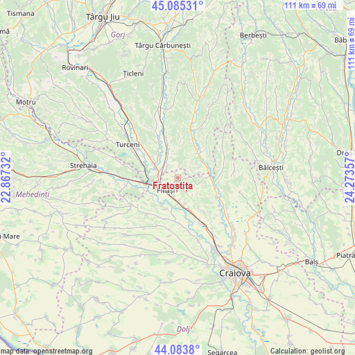
Fratoștița GPS coordinates[2]
44° 35' 12.156" North, 23° 34' 13.584" East
| Map corner | latitude | longitude |
|---|---|---|
| Upper-left | 45.08531°, | 22.86732° |
| Center: | 44.58671°, | 23.57044° |
| Lower-right: | 44.0838°, | 24.27357° |
| Map W x H: | 111.4×111.4 km | = 69.2×69.2mi |
| max Lat: | 48.23793° ⇑83.1% North |
| Fratoștița: | 44.58671° |
| min Lat: | ⇓16.9% South 43.65638° |
| min Long | Fratoștița | max Long |
| 20.31667° | 23.57044° | 29.65403° |
| W 24.1%⇐ | ⇒75.9% E |
Elevation
Elevation of Fratoștița is 174 m = 571 ft, and this is 80.9 m = 265 ft below average elevation for this country.
| Max E: |
1278 m = 4193 ft | 57.9% |
| Avg. | 254.9 m = 836 ft | |
| Fratoștița | 174 m = 571 ft | |
Min E: |
-2 m = -7 ft | 42.1% |
See also: Romania elevation on elevation.city.
Geographical zone
Fratoștița is located in North temperate zone (between Tropic of Cancer and the Arctic Circle). Distance of this Northern Tropic circle is 2351.7 km =1461.3 mi to South.| Distance of | km | miles | from Fratoștița |
|---|---|---|---|
| North Pole | 5049.5 | 3137.6 | to North |
| Arctic Circle | 2443.6 | 1518.4 | to North |
| Tropic Cancer | 2351.7 | 1461.3 | to South |
| Equator | 4957.6 | 3080.5 | to South |


Nearby cities:
15 places around Fratoștița: (largest is in red/bold)
• Braloştiţa
10.5 km =6.5 mi,  203°
203°
• Brăneşti
10.8 km =6.7 mi,  310°
310°
• Bâlta
9.8 km =6.1 mi,  234°
234°
• Capu Dealului
8.7 km =5.4 mi,  303°
303°
• Cocorova
7.9 km =4.9 mi,  352°
352°
• Crușeț
9.2 km =5.7 mi,  55°
55°
• Filiaşi
5.9 km =3.7 mi, 226°
• Florești
4.9 km =3 mi,  317°
317°
• Măiag
5 km =3.1 mi, 55°
• Poiana
7.9 km =4.9 mi,  336°
336°
• Răcarii de Jos
6.9 km =4.3 mi,  176°
176°
• Răcarii de Sus
5.8 km =3.6 mi,  190°
190°
• Sfârcea
11.3 km =7 mi, 189°
• Tatomirești
8.1 km =5 mi,  165°
165°
• Ţânţăreni
7.1 km =4.4 mi,  282°
282°
Sources, notices
• [Note1] Compared only with cities in Romania existing in our database
• [Src1] Map data: © OpenStreetMap contributors (CC-BY-SA)
• [Src2] Other city data from geonames.org with taken over terms of usage.
• [Src3] Geographical zone / Annual Mean Temperature by Robert A. Rohde @ Wikipedia
