Bâlta geodata
Bâlta (Dolj) is a populated place; located in Romania in Europe/Bucharest (GMT+3) time zone. With population of 1,203 people, there are 3733 cities with bigger population in this country. Compared to other cities in Romania, 84.4% of cities are located further ↑North; 77.4% of cities are located further →East and 76.7% of cities have higher elevation than Bâlta. Note1


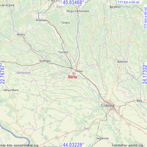
Bâlta GPS coordinates[2]
44° 32' 8.304" North, 23° 28' 12.684" East
| Map corner | latitude | longitude |
|---|---|---|
| Upper-left | 45.03468°, | 22.76707° |
| Center: | 44.53564°, | 23.47019° |
| Lower-right: | 44.03229°, | 24.17332° |
| Map W x H: | 111.5×111.5 km | = 69.3×69.3mi |
| max Lat: | 48.23793° ⇑84.4% North |
| Bâlta: | 44.53564° |
| min Lat: | ⇓15.6% South 43.65638° |
| min Long | Bâlta | max Long |
| 20.31667° | 23.47019° | 29.65403° |
| W 22.6%⇐ | ⇒77.4% E |
Elevation
Elevation of Bâlta is 105 m = 344 ft, and this is 149.9 m = 492 ft below average elevation for this country.
| Max E: |
1278 m = 4193 ft | 76.7% |
| Avg. | 254.9 m = 836 ft | |
| Bâlta | 105 m = 344 ft | |
Min E: |
-2 m = -7 ft | 23.3% |
See also: Romania elevation on elevation.city.
Geographical zone
Bâlta is located in North temperate zone (between Tropic of Cancer and the Arctic Circle). Distance of this Northern Tropic circle is 2346 km =1457.7 mi to South.| Distance of | km | miles | from Bâlta |
|---|---|---|---|
| North Pole | 5055.2 | 3141.2 | to North |
| Arctic Circle | 2449.3 | 1521.9 | to North |
| Tropic Cancer | 2346 | 1457.7 | to South |
| Equator | 4951.9 | 3077 | to South |


Nearby cities:
15 places around Bâlta: (largest is in red/bold)
• Argetoaia
8.5 km =5.3 mi,  255°
255°
• Arginești
6.1 km =3.8 mi,  314°
314°
• Braloştiţa
5.4 km =3.4 mi,  137°
137°
• Buicești
9 km =5.6 mi,  291°
291°
• Butoieşti
9.8 km =6.1 mi,  302°
302°
• Filiaşi
4 km =2.5 mi,  66°
66°
• Fratoștița
9.8 km =6.1 mi,  54°
54°
• Ioneşti
9.5 km =5.9 mi,  342°
342°
• Răcarii de Jos
8.5 km =5.3 mi,  98°
98°
• Răcarii de Sus
6.9 km =4.3 mi,  90°
90°
• Salcia
6.3 km =3.9 mi,  197°
197°
• Sfârcea
8.2 km =5.1 mi,  132°
132°
• Valea Fântânilor
3.9 km =2.4 mi,  163°
163°
• Valea lui Pătru
8.1 km =5 mi,  150°
150°
• Ţânţăreni
7.2 km =4.5 mi,  8°
8°
Sources, notices
• [Note1] Compared only with cities in Romania existing in our database
• [Src1] Map data: © OpenStreetMap contributors (CC-BY-SA)
• [Src2] Other city data from geonames.org with taken over terms of usage.
• [Src3] Geographical zone / Annual Mean Temperature by Robert A. Rohde @ Wikipedia
