Floroaia geodata
Floroaia (Covasna) is a populated place; located in Romania in Europe/Bucharest (GMT+3) time zone. With population of 1,148 people, there are 3860 cities with bigger population in this country. Compared to other cities in Romania, 52.2% of cities are located further ↑North; 63.2% of cities are located further ←West and 97% of cities have lower elevation than Floroaia. Note1


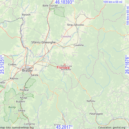
Floroaia GPS coordinates[2]
45° 41' 41.892" North, 26° 0' 56.268" East
| Map corner | latitude | longitude |
|---|---|---|
| Upper-left | 46.18393°, | 25.31251° |
| Center: | 45.69497°, | 26.01563° |
| Lower-right: | 45.2017°, | 26.71876° |
| Map W x H: | 109.2×109.2 km | = 67.9×67.9mi |
| max Lat: | 48.23793° ⇑52.2% North |
| Floroaia: | 45.69497° |
| min Lat: | ⇓47.8% South 43.65638° |
| min Long | Floroaia | max Long |
| 20.31667° | 26.01563° | 29.65403° |
| W 63.2%⇐ | ⇒36.8% E |
Elevation
Elevation of Floroaia is 719 m = 2359 ft, and this is 464.1 m = 1523 ft above average elevation for this country.
| Max E: |
1278 m = 4193 ft | 3% |
| Floroaia | 719 m 2359 ft | |
| Avg. | 254.9 m = 836 ft | |
Min E: |
-2 m = -7 ft | 97% |
See also: Romania elevation on elevation.city.
Geographical zone
Floroaia is located in North temperate zone (between Tropic of Cancer and the Arctic Circle). Distance of this North polar circle is 2320.4 km =1441.8 mi to North.| Distance of | km | miles | from Floroaia |
|---|---|---|---|
| North Pole | 4926.3 | 3061.1 | to North |
| Arctic Circle | 2320.4 | 1441.8 | to North |
| Tropic Cancer | 2474.9 | 1537.8 | to South |
| Equator | 5080.8 | 3157.1 | to South |


Nearby cities:
15 places around Floroaia: (largest is in red/bold)
• Acriș
6.7 km =4.2 mi,  195°
195°
• Barcani
5.3 km =3.3 mi,  83°
83°
• Brădet
5 km =3.1 mi, 200°
• Buzăiel
11.7 km =7.3 mi,  174°
174°
• Crivina
12.7 km =7.9 mi,  191°
191°
• Dobârlău
11.1 km =6.9 mi,  292°
292°
• Lădăuți
4.7 km =2.9 mi,  50°
50°
• Sita Buzăului
6.4 km =4 mi,  141°
141°
• Sărămaș
2.3 km =1.4 mi,  57°
57°
• Teliu
12.4 km =7.7 mi,  271°
271°
• Valea Mare
8.1 km =5 mi,  351°
351°
• Vama Buzăului
11.1 km =6.9 mi, 188°
• Zagon
11.2 km =7 mi,  44°
44°
• Zăbrătău
12.5 km =7.8 mi,  134°
134°
• Întorsura Buzăului
1.9 km =1.2 mi, 133°
Sources, notices
• [Note1] Compared only with cities in Romania existing in our database
• [Src1] Map data: © OpenStreetMap contributors (CC-BY-SA)
• [Src2] Other city data from geonames.org with taken over terms of usage.
• [Src3] Geographical zone / Annual Mean Temperature by Robert A. Rohde @ Wikipedia
