Brădet geodata
Brădet (Covasna) is a populated place; located in Romania in Europe/Bucharest (GMT+3) time zone. With population of 783 people, there are 5130 cities with bigger population in this country. Compared to other cities in Romania, 52.7% of cities are located further ↑North; 62.8% of cities are located further ←West and 97.2% of cities have lower elevation than Brădet. Note1


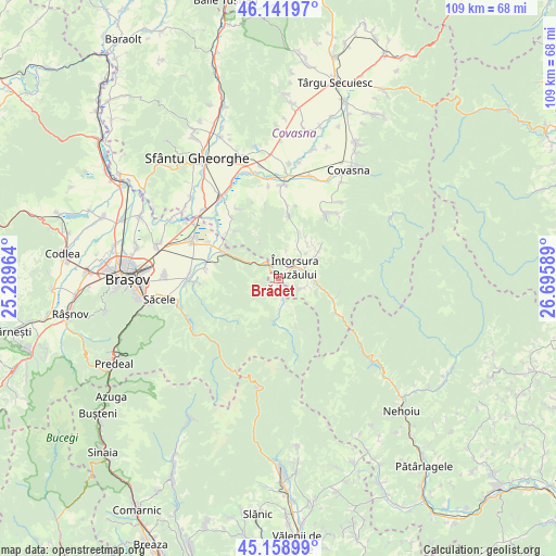
Brădet GPS coordinates[2]
45° 39' 9.504" North, 25° 59' 33.936" East
| Map corner | latitude | longitude |
|---|---|---|
| Upper-left | 46.14197°, | 25.28964° |
| Center: | 45.65264°, | 25.99276° |
| Lower-right: | 45.15899°, | 26.69589° |
| Map W x H: | 109.3×109.3 km | = 67.9×67.9mi |
| max Lat: | 48.23793° ⇑52.7% North |
| Brădet: | 45.65264° |
| min Lat: | ⇓47.3% South 43.65638° |
| min Long | Brădet | max Long |
| 20.31667° | 25.99276° | 29.65403° |
| W 62.8%⇐ | ⇒37.2% E |
Elevation
Elevation of Brădet is 728 m = 2388 ft, and this is 473.1 m = 1552 ft above average elevation for this country.
| Max E: |
1278 m = 4193 ft | 2.8% |
| Brădet | 728 m 2388 ft | |
| Avg. | 254.9 m = 836 ft | |
Min E: |
-2 m = -7 ft | 97.2% |
See also: Romania elevation on elevation.city.
Geographical zone
Brădet is located in North temperate zone (between Tropic of Cancer and the Arctic Circle). Distance of this North polar circle is 2325.1 km =1444.7 mi to North.| Distance of | km | miles | from Brădet |
|---|---|---|---|
| North Pole | 4931 | 3064 | to North |
| Arctic Circle | 2325.1 | 1444.7 | to North |
| Tropic Cancer | 2470.2 | 1534.9 | to South |
| Equator | 5076.1 | 3154.1 | to South |


Nearby cities:
15 places around Brădet: (largest is in red/bold)
• Acriș
1.8 km =1.1 mi,  180°
180°
• Barcani
8.8 km =5.5 mi,  53°
53°
• Buzăiel
7.5 km =4.7 mi,  156°
156°
• Crivina
7.7 km =4.8 mi,  185°
185°
• Dobârlău
12.4 km =7.7 mi,  316°
316°
• Dălghiu
11.1 km =6.9 mi,  215°
215°
• Floroaia
5 km =3.1 mi,  20°
20°
• Lădăuți
9.4 km =5.8 mi,  35°
35°
• Sita Buzăului
5.8 km =3.6 mi,  92°
92°
• Sărămaș
7 km =4.3 mi,  32°
32°
• Teliu
11.8 km =7.3 mi,  295°
295°
• Tunelu-Teliu
12.3 km =7.6 mi, 295°
• Vama Buzăului
6.2 km =3.9 mi, 179°
• Zăbrătău
11.5 km =7.1 mi,  110°
110°
• Întorsura Buzăului
4.6 km =2.9 mi, 42°
Sources, notices
• [Note1] Compared only with cities in Romania existing in our database
• [Src1] Map data: © OpenStreetMap contributors (CC-BY-SA)
• [Src2] Other city data from geonames.org with taken over terms of usage.
• [Src3] Geographical zone / Annual Mean Temperature by Robert A. Rohde @ Wikipedia
