Fârliug geodata
Fârliug (Caraş-Severin) is a seat of a second-order administrative division; located in Romania in Europe/Bucharest (GMT+3) time zone. With population of 2,186 people, there are 2437 cities with bigger population in this country. Compared to other cities in Romania, 55.5% of cities are located further ↑North; 95.5% of cities are located further →East and 55.8% of cities have higher elevation than Fârliug. Note1


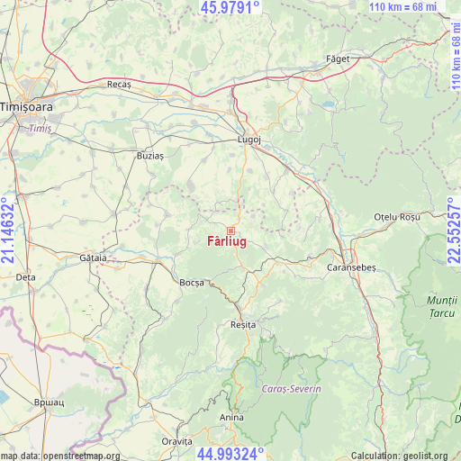
Fârliug GPS coordinates[2]
45° 29' 17.988" North, 21° 50' 57.984" East
| Map corner | latitude | longitude |
|---|---|---|
| Upper-left | 45.9791°, | 21.14632° |
| Center: | 45.48833°, | 21.84944° |
| Lower-right: | 44.99324°, | 22.55257° |
| Map W x H: | 109.6×109.6 km | = 68.1×68.1mi |
| max Lat: | 48.23793° ⇑55.5% North |
| Fârliug: | 45.48833° |
| min Lat: | ⇓44.5% South 43.65638° |
| min Long | Fârliug | max Long |
| 20.31667° | 21.84944° | 29.65403° |
| W 4.5%⇐ | ⇒95.5% E |
Elevation
Elevation of Fârliug is 183 m = 600 ft, and this is 71.9 m = 236 ft below average elevation for this country.
| Max E: |
1278 m = 4193 ft | 55.8% |
| Avg. | 254.9 m = 836 ft | |
| Fârliug | 183 m = 600 ft | |
Min E: |
-2 m = -7 ft | 44.2% |
See also: Romania elevation on elevation.city.
Geographical zone
Fârliug is located in North temperate zone (between Tropic of Cancer and the Arctic Circle). Distance of this North polar circle is 2343.3 km =1456.1 mi to North.| Distance of | km | miles | from Fârliug |
|---|---|---|---|
| North Pole | 4949.2 | 3075.3 | to North |
| Arctic Circle | 2343.3 | 1456.1 | to North |
| Tropic Cancer | 2451.9 | 1523.5 | to South |
| Equator | 5057.8 | 3142.8 | to South |


Nearby cities:
15 places around Fârliug: (largest is in red/bold)
• Bocşa
16.8 km =10.4 mi,  220°
220°
• Brebu
13.5 km =8.4 mi,  124°
124°
• Câlnic
16.7 km =10.4 mi,  177°
177°
• Ezeriş
9.1 km =5.7 mi,  161°
161°
• Petroasa Mare
14.4 km =8.9 mi,  358°
358°
• Ramna
13.7 km =8.5 mi,  246°
246°
• Sacoșu Mare
14.2 km =8.8 mi,  319°
319°
• Soceni
15 km =9.3 mi,  149°
149°
• Valeapai
9.8 km =6.1 mi,  272°
272°
• Vermeş
15.2 km =9.4 mi,  283°
283°
• Victor Vlad Delamarina
17.3 km =10.7 mi,  11°
11°
• Vișag
7.4 km =4.6 mi,  336°
336°
• Zorile
16.7 km =10.4 mi,  88°
88°
• Zorlenţu Mare
9.3 km =5.8 mi, 116°
• Ştiuca
13.5 km =8.4 mi,  47°
47°
Sources, notices
• [Note1] Compared only with cities in Romania existing in our database
• [Src1] Map data: © OpenStreetMap contributors (CC-BY-SA)
• [Src2] Other city data from geonames.org with taken over terms of usage.
• [Src3] Geographical zone / Annual Mean Temperature by Robert A. Rohde @ Wikipedia
