Bogdăneşti geodata
Bogdăneşti (Bacău) is a seat of a second-order administrative division; located in Romania in Europe/Bucharest (GMT+3) time zone. With population of 2,740 people, there are 1954 cities with bigger population in this country. Compared to other cities in Romania, 59.9% of cities are located further ↓South; 76.2% of cities are located further ←West and 61.2% of cities have lower elevation than Bogdăneşti. Note1


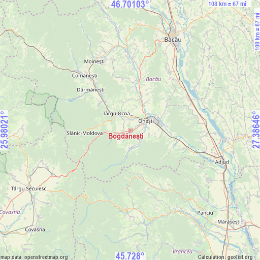
Bogdăneşti GPS coordinates[2]
46° 13' 0.012" North, 26° 40' 59.988" East
| Map corner | latitude | longitude |
|---|---|---|
| Upper-left | 46.70103°, | 25.98021° |
| Center: | 46.21667°, | 26.68333° |
| Lower-right: | 45.728°, | 27.38646° |
| Map W x H: | 108.2×108.2 km | = 67.2×67.2mi |
| max Lat: | 48.23793° ⇑40.1% North |
| Bogdăneşti: | 46.21667° |
| min Lat: | ⇓59.9% South 43.65638° |
| min Long | Bogdăneşti | max Long |
| 20.31667° | 26.68333° | 29.65403° |
| W 76.2%⇐ | ⇒23.8% E |
Elevation
Elevation of Bogdăneşti is 270 m = 886 ft, and this is 15.1 m = 50 ft above average elevation for this country.
| Max E: |
1278 m = 4193 ft | 38.8% |
| Bogdăneşti | 270 m 886 ft | |
| Avg. | 254.9 m = 836 ft | |
Min E: |
-2 m = -7 ft | 61.2% |
See also: Romania elevation on elevation.city.
Geographical zone
Bogdăneşti is located in North temperate zone (between Tropic of Cancer and the Arctic Circle). Distance of this North polar circle is 2262.4 km =1405.8 mi to North.| Distance of | km | miles | from Bogdăneşti |
|---|---|---|---|
| North Pole | 4868.2 | 3025 | to North |
| Arctic Circle | 2262.4 | 1405.8 | to North |
| Tropic Cancer | 2532.9 | 1573.9 | to South |
| Equator | 5138.8 | 3193.1 | to South |


Nearby cities:
15 places around Bogdăneşti: (largest is in red/bold)
• Bahna
2.7 km =1.7 mi,  292°
292°
• Caşin
5.5 km =3.4 mi,  109°
109°
• Curița
3.6 km =2.2 mi,  141°
141°
• Filipești
2.7 km =1.7 mi,  73°
73°
• Lupești
6.8 km =4.2 mi,  145°
145°
• Marginea
3.5 km =2.2 mi,  269°
269°
• Mânăstirea Caşin
7.4 km =4.6 mi,  180°
180°
• Nicorești
3.3 km =2.1 mi,  307°
307°
• Oituz
5.5 km =3.4 mi,  250°
250°
• Onesti
6.3 km =3.9 mi,  54°
54°
• Pârgăreşti
4.5 km =2.8 mi,  325°
325°
• Satu Nou
3.9 km =2.4 mi,  323°
323°
• Tuta
4.5 km =2.8 mi,  7°
7°
• Târgu Trotuş
5.7 km =3.5 mi,  347°
347°
• Viișoara
7.6 km =4.7 mi, 347°
Sources, notices
• [Note1] Compared only with cities in Romania existing in our database
• [Src1] Map data: © OpenStreetMap contributors (CC-BY-SA)
• [Src2] Other city data from geonames.org with taken over terms of usage.
• [Src3] Geographical zone / Annual Mean Temperature by Robert A. Rohde @ Wikipedia
