Bahna geodata
Bahna (Bacău) is a populated place; located in Romania in Europe/Bucharest (GMT+3) time zone. With population of 594 people, there are 6243 cities with bigger population in this country. Compared to other cities in Romania, 60.2% of cities are located further ↓South; 75.7% of cities are located further ←West and 68.6% of cities have lower elevation than Bahna. Note1


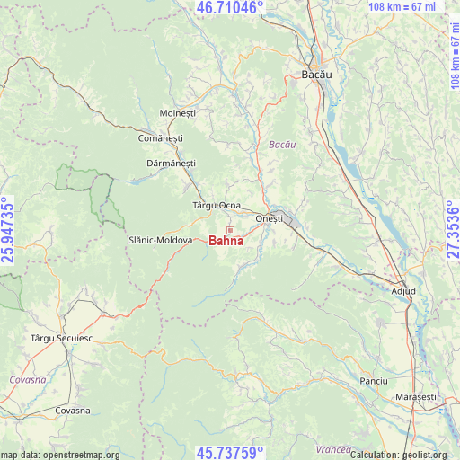
Bahna GPS coordinates[2]
46° 13' 34.248" North, 26° 39' 1.692" East
| Map corner | latitude | longitude |
|---|---|---|
| Upper-left | 46.71046°, | 25.94735° |
| Center: | 46.22618°, | 26.65047° |
| Lower-right: | 45.73759°, | 27.3536° |
| Map W x H: | 108.2×108.2 km | = 67.2×67.2mi |
| max Lat: | 48.23793° ⇑39.8% North |
| Bahna: | 46.22618° |
| min Lat: | ⇓60.2% South 43.65638° |
| min Long | Bahna | max Long |
| 20.31667° | 26.65047° | 29.65403° |
| W 75.7%⇐ | ⇒24.3% E |
Elevation
Elevation of Bahna is 310 m = 1017 ft, and this is 55.1 m = 181 ft above average elevation for this country.
| Max E: |
1278 m = 4193 ft | 31.4% |
| Bahna | 310 m 1017 ft | |
| Avg. | 254.9 m = 836 ft | |
Min E: |
-2 m = -7 ft | 68.6% |
See also: Romania elevation on elevation.city.
Geographical zone
Bahna is located in North temperate zone (between Tropic of Cancer and the Arctic Circle). Distance of this North polar circle is 2261.3 km =1405.1 mi to North.| Distance of | km | miles | from Bahna |
|---|---|---|---|
| North Pole | 4867.2 | 3024.3 | to North |
| Arctic Circle | 2261.3 | 1405.1 | to North |
| Tropic Cancer | 2534 | 1574.6 | to South |
| Equator | 5139.9 | 3193.8 | to South |


Nearby cities:
15 places around Bahna: (largest is in red/bold)
• Bogdăneşti
2.7 km =1.7 mi,  112°
112°
• Caşin
8.2 km =5.1 mi, 110°
• Curița
6.2 km =3.9 mi,  129°
129°
• Ferestrău-Oituz
6.3 km =3.9 mi,  245°
245°
• Filipești
5.1 km =3.2 mi,  93°
93°
• Marginea
1.5 km =0.9 mi,  222°
222°
• Nicorești
1 km =0.6 mi,  353°
353°
• Oituz
3.9 km =2.4 mi, 221°
• Onesti
8.1 km =5 mi,  70°
70°
• Pârgăreşti
2.6 km =1.6 mi,  359°
359°
• Satu Nou
2 km =1.2 mi,  6°
6°
• Tuta
4.6 km =2.9 mi,  42°
42°
• Târgu Ocna
6.5 km =4 mi,  333°
333°
• Târgu Trotuş
4.7 km =2.9 mi,  15°
15°
• Viișoara
6.4 km =4 mi, 7°
Sources, notices
• [Note1] Compared only with cities in Romania existing in our database
• [Src1] Map data: © OpenStreetMap contributors (CC-BY-SA)
• [Src2] Other city data from geonames.org with taken over terms of usage.
• [Src3] Geographical zone / Annual Mean Temperature by Robert A. Rohde @ Wikipedia
