Făgăraș geodata
Făgăraș (Braşov) is a seat of a second-order administrative division; located in Romania in Europe/Bucharest (GMT+3) time zone. With population of 30,714 people, there are 69 cities with bigger population in this country. Compared to other cities in Romania, 51.4% of cities are located further ↓South; 53.1% of cities are located further →East and 82.7% of cities have lower elevation than Făgăraș. Note1


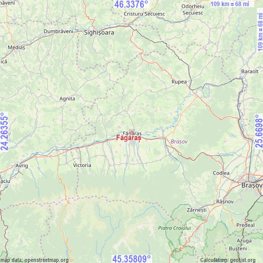
Făgăraș GPS coordinates[2]
45° 51' 0" North, 24° 58' 0.012" East
| Map corner | latitude | longitude |
|---|---|---|
| Upper-left | 46.3376°, | 24.26355° |
| Center: | 45.85°, | 24.96667° |
| Lower-right: | 45.35809°, | 25.6698° |
| Map W x H: | 108.9×108.9 km | = 67.7×67.7mi |
| max Lat: | 48.23793° ⇑48.6% North |
| Făgăraș: | 45.85° |
| min Lat: | ⇓51.4% South 43.65638° |
| min Long | Făgăraș | max Long |
| 20.31667° | 24.96667° | 29.65403° |
| W 46.9%⇐ | ⇒53.1% E |
Elevation
Elevation of Făgăraș is 420 m = 1378 ft, and this is 165.1 m = 542 ft above average elevation for this country.
| Max E: |
1278 m = 4193 ft | 17.3% |
| Făgăraș | 420 m 1378 ft | |
| Avg. | 254.9 m = 836 ft | |
Min E: |
-2 m = -7 ft | 82.7% |
See also: Romania elevation on elevation.city.
Geographical zone
Făgăraș is located in North temperate zone (between Tropic of Cancer and the Arctic Circle). Distance of this North polar circle is 2303.1 km =1431.1 mi to North.| Distance of | km | miles | from Făgăraș |
|---|---|---|---|
| North Pole | 4909 | 3050.3 | to North |
| Arctic Circle | 2303.1 | 1431.1 | to North |
| Tropic Cancer | 2492.1 | 1548.5 | to South |
| Equator | 5098 | 3167.7 | to South |


Nearby cities:
15 places around Făgăraș: (largest is in red/bold)
• Beclean
4.1 km =2.5 mi,  238°
238°
• Berivoi
13 km =8.1 mi,  174°
174°
• Cincșor
10.4 km =6.5 mi,  262°
262°
• Copăcel
11.8 km =7.3 mi, 169°
• Hârşeni
11.8 km =7.3 mi,  160°
160°
• Hălmeag
13 km =8.1 mi,  82°
82°
• Ileni
7.4 km =4.6 mi, 158°
• Mândra
7.4 km =4.6 mi,  119°
119°
• Sebeș
14.6 km =9.1 mi, 159°
• Sâmbăta de Jos
12.1 km =7.5 mi,  249°
249°
• Ticuşu Vechi
13.9 km =8.6 mi,  48°
48°
• Voila
10.3 km =6.4 mi, 249°
• Voivodeni
11.3 km =7 mi,  226°
226°
• Şercaia
13 km =8.1 mi,  98°
98°
• Şoarş
9.2 km =5.7 mi,  341°
341°
Sources, notices
• [Note1] Compared only with cities in Romania existing in our database
• [Src1] Map data: © OpenStreetMap contributors (CC-BY-SA)
• [Src2] Other city data from geonames.org with taken over terms of usage.
• [Src3] Geographical zone / Annual Mean Temperature by Robert A. Rohde @ Wikipedia
