Dulcești geodata
Dulcești (Constanța) is a populated place; located in Romania in Europe/Bucharest (GMT+3) time zone. With population of 1,315 people, there are 3488 cities with bigger population in this country. Compared to other cities in Romania, 98.3% of cities are located further ↑North; 98.8% of cities are located further ←West and 99.3% of cities have higher elevation than Dulcești. Note1


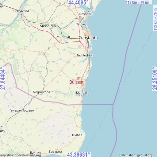
Dulcești GPS coordinates[2]
43° 54' 18.216" North, 28° 32' 52.656" East
| Map corner | latitude | longitude |
|---|---|---|
| Upper-left | 44.4095°, | 27.84484° |
| Center: | 43.90506°, | 28.54796° |
| Lower-right: | 43.39631°, | 29.25109° |
| Map W x H: | 112.7×112.7 km | = 70×70mi |
| max Lat: | 48.23793° ⇑98.3% North |
| Dulcești: | 43.90506° |
| min Lat: | ⇓1.7% South 43.65638° |
| min Long | Dulcești | max Long |
| 20.31667° | 28.54796° | 29.65403° |
| W 98.8%⇐ | ⇒1.2% E |
Elevation
Elevation of Dulcești is 9 m = 30 ft, and this is 245.9 m = 807 ft below average elevation for this country.
| Max E: |
1278 m = 4193 ft | 99.3% |
| Avg. | 254.9 m = 836 ft | |
| Dulcești | 9 m = 30 ft | |
Min E: |
-2 m = -7 ft | 0.7% |
See also: Romania elevation on elevation.city.
Geographical zone
Dulcești is located in North temperate zone (between Tropic of Cancer and the Arctic Circle). Distance of this Northern Tropic circle is 2275.9 km =1414.2 mi to South.| Distance of | km | miles | from Dulcești |
|---|---|---|---|
| North Pole | 5125.3 | 3184.7 | to North |
| Arctic Circle | 2519.4 | 1565.5 | to North |
| Tropic Cancer | 2275.9 | 1414.2 | to South |
| Equator | 4881.8 | 3033.4 | to South |


Nearby cities:
15 places around Dulcești: (largest is in red/bold)
• 23 August
3.1 km =1.9 mi,  65°
65°
• Amzacea
12.9 km =8 mi,  292°
292°
• Arsa
9.9 km =6.2 mi,  222°
222°
• Biruința
10.5 km =6.5 mi,  341°
341°
• Costineşti
8.5 km =5.3 mi,  53°
53°
• Eforie Sud
15.4 km =9.6 mi,  31°
31°
• Limanu
11.7 km =7.3 mi,  185°
185°
• Mangalia
12 km =7.5 mi,  166°
166°
• Moșneni
3.6 km =2.2 mi, 338°
• Neptun
5.7 km =3.5 mi,  131°
131°
• Pecineaga
3.9 km =2.4 mi,  261°
261°
• Schitu
7.7 km =4.8 mi,  56°
56°
• Topraisar
14.7 km =9.1 mi,  327°
327°
• Tuzla
12.6 km =7.8 mi, 32°
• Tătaru
15.3 km =9.5 mi, 259°
Sources, notices
• [Note1] Compared only with cities in Romania existing in our database
• [Src1] Map data: © OpenStreetMap contributors (CC-BY-SA)
• [Src2] Other city data from geonames.org with taken over terms of usage.
• [Src3] Geographical zone / Annual Mean Temperature by Robert A. Rohde @ Wikipedia
