Tătaru geodata
Tătaru (Constanța) is a populated place; located in Romania in Europe/Bucharest (GMT+3) time zone. With population of 643 people, there are 5921 cities with bigger population in this country. Compared to other cities in Romania, 98.7% of cities are located further ↑North; 98.2% of cities are located further ←West and 77% of cities have higher elevation than Tătaru. Note1


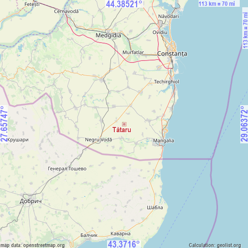
Tătaru GPS coordinates[2]
43° 52' 50.016" North, 28° 21' 38.124" East
| Map corner | latitude | longitude |
|---|---|---|
| Upper-left | 44.38521°, | 27.65747° |
| Center: | 43.88056°, | 28.36059° |
| Lower-right: | 43.3716°, | 29.06372° |
| Map W x H: | 112.7×112.7 km | = 70×70mi |
| max Lat: | 48.23793° ⇑98.7% North |
| Tătaru: | 43.88056° |
| min Lat: | ⇓1.3% South 43.65638° |
| min Long | Tătaru | max Long |
| 20.31667° | 28.36059° | 29.65403° |
| W 98.2%⇐ | ⇒1.8% E |
Elevation
Elevation of Tătaru is 104 m = 341 ft, and this is 150.9 m = 495 ft below average elevation for this country.
| Max E: |
1278 m = 4193 ft | 77% |
| Avg. | 254.9 m = 836 ft | |
| Tătaru | 104 m = 341 ft | |
Min E: |
-2 m = -7 ft | 23% |
See also: Romania elevation on elevation.city.
Geographical zone
Tătaru is located in North temperate zone (between Tropic of Cancer and the Arctic Circle). Distance of this Northern Tropic circle is 2273.1 km =1412.4 mi to South.| Distance of | km | miles | from Tătaru |
|---|---|---|---|
| North Pole | 5128 | 3186.4 | to North |
| Arctic Circle | 2522.1 | 1567.2 | to North |
| Tropic Cancer | 2273.1 | 1412.4 | to South |
| Equator | 4879.1 | 3031.7 | to South |


Nearby cities:
15 places around Tătaru: (largest is in red/bold)
• Albeşti
10 km =6.2 mi,  153°
153°
• Amzacea
8.3 km =5.2 mi,  22°
22°
• Arsa
9.6 km =6 mi,  119°
119°
• Chirnogeni
10.4 km =6.5 mi,  281°
281°
• Comana
4.1 km =2.5 mi,  301°
301°
• Cotu Văii
6.5 km =4 mi,  190°
190°
• Darabani
11.6 km =7.2 mi,  206°
206°
• Dulcești
15.3 km =9.5 mi,  79°
79°
• General Scărișoreanu
9.5 km =5.9 mi,  329°
329°
• Limanu
16.5 km =10.3 mi, 122°
• Moșneni
15 km =9.3 mi,  66°
66°
• Negru Vodă
14.7 km =9.1 mi,  241°
241°
• Osmancea
15.2 km =9.4 mi,  348°
348°
• Pecineaga
11.4 km =7.1 mi, 79°
• Plopeni
15.4 km =9.6 mi, 300°
Sources, notices
• [Note1] Compared only with cities in Romania existing in our database
• [Src1] Map data: © OpenStreetMap contributors (CC-BY-SA)
• [Src2] Other city data from geonames.org with taken over terms of usage.
• [Src3] Geographical zone / Annual Mean Temperature by Robert A. Rohde @ Wikipedia
