Moșneni geodata
Moșneni (Constanța) is a populated place; located in Romania in Europe/Bucharest (GMT+3) time zone. With population of 1,266 people, there are 3602 cities with bigger population in this country. Compared to other cities in Romania, 97.9% of cities are located further ↑North; 98.8% of cities are located further ←West and 92.6% of cities have higher elevation than Moșneni. Note1


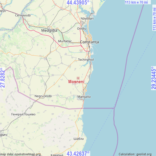
Moșneni GPS coordinates[2]
43° 56' 5.532" North, 28° 31' 52.752" East
| Map corner | latitude | longitude |
|---|---|---|
| Upper-left | 44.43905°, | 27.8282° |
| Center: | 43.93487°, | 28.53132° |
| Lower-right: | 43.42637°, | 29.23445° |
| Map W x H: | 112.6×112.6 km | = 70×70mi |
| max Lat: | 48.23793° ⇑97.9% North |
| Moșneni: | 43.93487° |
| min Lat: | ⇓2.1% South 43.65638° |
| min Long | Moșneni | max Long |
| 20.31667° | 28.53132° | 29.65403° |
| W 98.8%⇐ | ⇒1.2% E |
Elevation
Elevation of Moșneni is 46 m = 151 ft, and this is 208.9 m = 685 ft below average elevation for this country.
| Max E: |
1278 m = 4193 ft | 92.6% |
| Avg. | 254.9 m = 836 ft | |
| Moșneni | 46 m = 151 ft | |
Min E: |
-2 m = -7 ft | 7.4% |
See also: Romania elevation on elevation.city.
Geographical zone
Moșneni is located in North temperate zone (between Tropic of Cancer and the Arctic Circle). Distance of this Northern Tropic circle is 2279.2 km =1416.2 mi to South.| Distance of | km | miles | from Moșneni |
|---|---|---|---|
| North Pole | 5122 | 3182.7 | to North |
| Arctic Circle | 2516.1 | 1563.4 | to North |
| Tropic Cancer | 2279.2 | 1416.2 | to South |
| Equator | 4885.1 | 3035.5 | to South |


Nearby cities:
15 places around Moșneni: (largest is in red/bold)
• 23 August
4.6 km =2.9 mi,  115°
115°
• Amzacea
10.6 km =6.6 mi,  279°
279°
• Arsa
11.9 km =7.4 mi,  206°
206°
• Biruința
7 km =4.3 mi,  343°
343°
• Costineşti
8.3 km =5.2 mi,  78°
78°
• Dulcești
3.6 km =2.2 mi,  158°
158°
• Eforie
14.9 km =9.3 mi,  38°
38°
• Eforie Sud
13.6 km =8.5 mi, 43°
• Movilița
12.4 km =7.7 mi,  352°
352°
• Neptun
9 km =5.6 mi,  141°
141°
• Pecineaga
4.6 km =2.9 mi, 212°
• Schitu
7.8 km =4.8 mi, 83°
• Techirghiol
13.9 km =8.6 mi,  23°
23°
• Topraisar
11.2 km =7 mi,  324°
324°
• Tuzla
10.9 km =6.8 mi,  48°
48°
Sources, notices
• [Note1] Compared only with cities in Romania existing in our database
• [Src1] Map data: © OpenStreetMap contributors (CC-BY-SA)
• [Src2] Other city data from geonames.org with taken over terms of usage.
• [Src3] Geographical zone / Annual Mean Temperature by Robert A. Rohde @ Wikipedia
