Dobroteşti geodata
Dobroteşti (Teleorman) is a seat of a second-order administrative division; located in Romania in Europe/Bucharest (GMT+3) time zone. With population of 5,096 people, there are 749 cities with bigger population in this country. Compared to other cities in Romania, 91.3% of cities are located further ↑North; 54.4% of cities are located further →East and 72.9% of cities have higher elevation than Dobroteşti. Note1


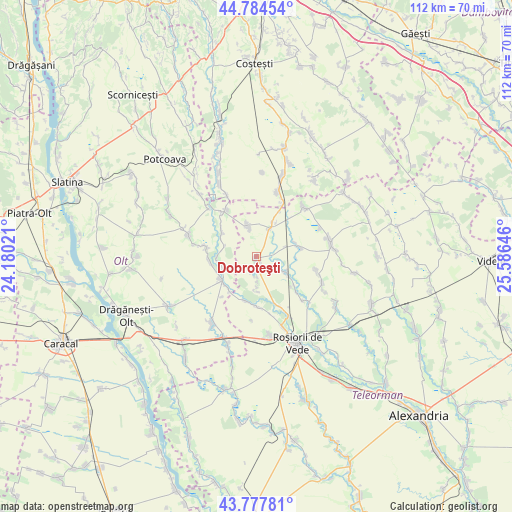
Dobroteşti GPS coordinates[2]
44° 16' 59.988" North, 24° 52' 59.988" East
| Map corner | latitude | longitude |
|---|---|---|
| Upper-left | 44.78454°, | 24.18021° |
| Center: | 44.28333°, | 24.88333° |
| Lower-right: | 43.77781°, | 25.58646° |
| Map W x H: | 111.9×111.9 km | = 69.5×69.5mi |
| max Lat: | 48.23793° ⇑91.3% North |
| Dobroteşti: | 44.28333° |
| min Lat: | ⇓8.7% South 43.65638° |
| min Long | Dobroteşti | max Long |
| 20.31667° | 24.88333° | 29.65403° |
| W 45.6%⇐ | ⇒54.4% E |
Elevation
Elevation of Dobroteşti is 117 m = 384 ft, and this is 137.9 m = 452 ft below average elevation for this country.
| Max E: |
1278 m = 4193 ft | 72.9% |
| Avg. | 254.9 m = 836 ft | |
| Dobroteşti | 117 m = 384 ft | |
Min E: |
-2 m = -7 ft | 27.1% |
See also: Romania elevation on elevation.city.
Geographical zone
Dobroteşti is located in North temperate zone (between Tropic of Cancer and the Arctic Circle). Distance of this Northern Tropic circle is 2317.9 km =1440.3 mi to South.| Distance of | km | miles | from Dobroteşti |
|---|---|---|---|
| North Pole | 5083.2 | 3158.6 | to North |
| Arctic Circle | 2477.3 | 1539.3 | to North |
| Tropic Cancer | 2317.9 | 1440.3 | to South |
| Equator | 4923.8 | 3059.5 | to South |


Nearby cities:
15 places around Dobroteşti: (largest is in red/bold)
• Balaci
7.9 km =4.9 mi,  19°
19°
• Barza
9.7 km =6 mi,  304°
304°
• Beuca
7.5 km =4.7 mi,  117°
117°
• Didești
7.4 km =4.6 mi,  180°
180°
• Drăcșenei
10.3 km =6.4 mi,  127°
127°
• Ghimpețeni
8.7 km =5.4 mi,  268°
268°
• Ghimpețenii Noi
7.5 km =4.7 mi,  283°
283°
• Merișani
3.5 km =2.2 mi,  190°
190°
• Nicolae Titulescu
6.9 km =4.3 mi,  285°
285°
• Satu Nou
6.9 km =4.3 mi,  173°
173°
• Socetu
10.1 km =6.3 mi, 193°
• Stoborăști
10.1 km =6.3 mi,  309°
309°
• Tecuci
6.8 km =4.2 mi,  343°
343°
• Văleni
9.7 km =6 mi,  235°
235°
• Zâmbreasca
8.8 km =5.5 mi,  65°
65°
Sources, notices
• [Note1] Compared only with cities in Romania existing in our database
• [Src1] Map data: © OpenStreetMap contributors (CC-BY-SA)
• [Src2] Other city data from geonames.org with taken over terms of usage.
• [Src3] Geographical zone / Annual Mean Temperature by Robert A. Rohde @ Wikipedia
