Ghimpețeni geodata
Ghimpețeni (Olt) is a seat of a second-order administrative division; located in Romania in Europe/Bucharest (GMT+3) time zone. With population of 1,213 people, there are 3718 cities with bigger population in this country. Compared to other cities in Romania, 91.4% of cities are located further ↑North; 55.9% of cities are located further →East and 73.3% of cities have higher elevation than Ghimpețeni. Note1


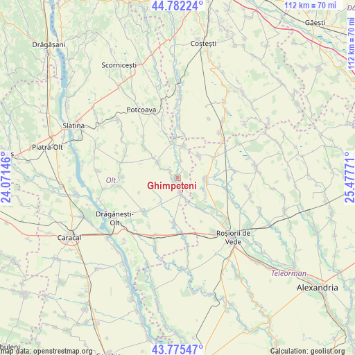
Ghimpețeni GPS coordinates[2]
44° 16' 51.636" North, 24° 46' 28.488" East
| Map corner | latitude | longitude |
|---|---|---|
| Upper-left | 44.78224°, | 24.07146° |
| Center: | 44.28101°, | 24.77458° |
| Lower-right: | 43.77547°, | 25.47771° |
| Map W x H: | 111.9×111.9 km | = 69.5×69.5mi |
| max Lat: | 48.23793° ⇑91.4% North |
| Ghimpețeni: | 44.28101° |
| min Lat: | ⇓8.6% South 43.65638° |
| min Long | Ghimpețeni | max Long |
| 20.31667° | 24.77458° | 29.65403° |
| W 44.1%⇐ | ⇒55.9% E |
Elevation
Elevation of Ghimpețeni is 116 m = 381 ft, and this is 138.9 m = 456 ft below average elevation for this country.
| Max E: |
1278 m = 4193 ft | 73.3% |
| Avg. | 254.9 m = 836 ft | |
| Ghimpețeni | 116 m = 381 ft | |
Min E: |
-2 m = -7 ft | 26.7% |
See also: Romania elevation on elevation.city.
Geographical zone
Ghimpețeni is located in North temperate zone (between Tropic of Cancer and the Arctic Circle). Distance of this Northern Tropic circle is 2317.7 km =1440.2 mi to South.| Distance of | km | miles | from Ghimpețeni |
|---|---|---|---|
| North Pole | 5083.5 | 3158.7 | to North |
| Arctic Circle | 2477.6 | 1539.5 | to North |
| Tropic Cancer | 2317.7 | 1440.2 | to South |
| Equator | 4923.6 | 3059.4 | to South |


Nearby cities:
15 places around Ghimpețeni: (largest is in red/bold)
• Barza
5.9 km =3.7 mi,  6°
6°
• Buta
6 km =3.7 mi,  300°
300°
• Crâmpoia
3.3 km =2.1 mi,  315°
315°
• Dobroteşti
8.7 km =5.4 mi,  88°
88°
• Floru
10.7 km =6.6 mi,  352°
352°
• Ghimpețenii Noi
2.4 km =1.5 mi,  33°
33°
• Ghioca
5.1 km =3.2 mi, 320°
• Merișani
8.7 km =5.4 mi,  111°
111°
• Nicolae Titulescu
2.9 km =1.8 mi,  43°
43°
• Stoborăști
6.8 km =4.2 mi, 7°
• Tecuci
9.6 km =6 mi,  45°
45°
• Tufeni
9.5 km =5.9 mi,  4°
4°
• Văleni
5.3 km =3.3 mi,  172°
172°
• Şerbăneşti
8.3 km =5.2 mi,  314°
314°
• Șerbăneștii de Sus
9.6 km =6 mi, 310°
Sources, notices
• [Note1] Compared only with cities in Romania existing in our database
• [Src1] Map data: © OpenStreetMap contributors (CC-BY-SA)
• [Src2] Other city data from geonames.org with taken over terms of usage.
• [Src3] Geographical zone / Annual Mean Temperature by Robert A. Rohde @ Wikipedia
