Barza geodata
Barza (Olt) is a populated place; located in Romania in Europe/Bucharest (GMT+3) time zone. With population of 2,677 people, there are 1998 cities with bigger population in this country. Compared to other cities in Romania, 90.1% of cities are located further ↑North; 55.8% of cities are located further →East and 70.2% of cities have higher elevation than Barza. Note1


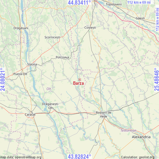
Barza GPS coordinates[2]
44° 19' 59.988" North, 24° 46' 59.988" East
| Map corner | latitude | longitude |
|---|---|---|
| Upper-left | 44.83411°, | 24.08021° |
| Center: | 44.33333°, | 24.78333° |
| Lower-right: | 43.82824°, | 25.48646° |
| Map W x H: | 111.8×111.8 km | = 69.5×69.5mi |
| max Lat: | 48.23793° ⇑90.1% North |
| Barza: | 44.33333° |
| min Lat: | ⇓9.9% South 43.65638° |
| min Long | Barza | max Long |
| 20.31667° | 24.78333° | 29.65403° |
| W 44.2%⇐ | ⇒55.8% E |
Elevation
Elevation of Barza is 126 m = 413 ft, and this is 128.9 m = 423 ft below average elevation for this country.
| Max E: |
1278 m = 4193 ft | 70.2% |
| Avg. | 254.9 m = 836 ft | |
| Barza | 126 m = 413 ft | |
Min E: |
-2 m = -7 ft | 29.8% |
See also: Romania elevation on elevation.city.
Geographical zone
Barza is located in North temperate zone (between Tropic of Cancer and the Arctic Circle). Distance of this Northern Tropic circle is 2323.5 km =1443.8 mi to South.| Distance of | km | miles | from Barza |
|---|---|---|---|
| North Pole | 5077.7 | 3155.1 | to North |
| Arctic Circle | 2471.8 | 1535.9 | to North |
| Tropic Cancer | 2323.5 | 1443.8 | to South |
| Equator | 4929.4 | 3063 | to South |


Nearby cities:
15 places around Barza: (largest is in red/bold)
• Buta
6.5 km =4 mi,  244°
244°
• Bârla
10.3 km =6.4 mi,  357°
357°
• Crâmpoia
4.6 km =2.9 mi,  221°
221°
• Dobroteşti
9.7 km =6 mi,  124°
124°
• Floru
5.2 km =3.2 mi,  335°
335°
• Ghimpețeni
5.9 km =3.7 mi,  186°
186°
• Ghimpețenii Noi
3.9 km =2.4 mi,  170°
170°
• Ghioca
4.4 km =2.7 mi,  245°
245°
• Mozăcenii-Vale
7.5 km =4.7 mi,  10°
10°
• Nicolae Titulescu
3.9 km =2.4 mi,  160°
160°
• Stoborăști
0.9 km =0.6 mi, 12°
• Tecuci
6.1 km =3.8 mi,  81°
81°
• Tufeni
3.7 km =2.3 mi,  0°
0°
• Şerbăneşti
6.6 km =4.1 mi,  270°
270°
• Șerbăneștii de Sus
8 km =5 mi, 272°
Sources, notices
• [Note1] Compared only with cities in Romania existing in our database
• [Src1] Map data: © OpenStreetMap contributors (CC-BY-SA)
• [Src2] Other city data from geonames.org with taken over terms of usage.
• [Src3] Geographical zone / Annual Mean Temperature by Robert A. Rohde @ Wikipedia
