Doba geodata
Doba (Sălaj) is a populated place; located in Romania in Europe/Bucharest (GMT+3) time zone. With population of 713 people, there are 5491 cities with bigger population in this country. Compared to other cities in Romania, 86.4% of cities are located further ↓South; 83.1% of cities are located further →East and 50.3% of cities have lower elevation than Doba. Note1


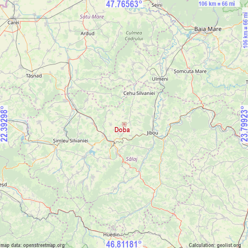
Doba GPS coordinates[2]
47° 17' 27.132" North, 23° 5' 45.96" East
| Map corner | latitude | longitude |
|---|---|---|
| Upper-left | 47.76563°, | 22.39298° |
| Center: | 47.29087°, | 23.0961° |
| Lower-right: | 46.81181°, | 23.79923° |
| Map W x H: | 106.1×106.1 km | = 65.9×65.9mi |
| max Lat: | 48.23793° ⇑13.6% North |
| Doba: | 47.29087° |
| min Lat: | ⇓86.4% South 43.65638° |
| min Long | Doba | max Long |
| 20.31667° | 23.0961° | 29.65403° |
| W 16.9%⇐ | ⇒83.1% E |
Elevation
Elevation of Doba is 213 m = 699 ft, and this is 41.9 m = 137 ft below average elevation for this country.
| Max E: |
1278 m = 4193 ft | 49.7% |
| Avg. | 254.9 m = 836 ft | |
| Doba | 213 m = 699 ft | |
Min E: |
-2 m = -7 ft | 50.3% |
See also: Romania elevation on elevation.city.
Geographical zone
Doba is located in North temperate zone (between Tropic of Cancer and the Arctic Circle). Distance of this North polar circle is 2142.9 km =1331.5 mi to North.| Distance of | km | miles | from Doba |
|---|---|---|---|
| North Pole | 4748.8 | 2950.8 | to North |
| Arctic Circle | 2142.9 | 1331.5 | to North |
| Tropic Cancer | 2652.3 | 1648.1 | to South |
| Equator | 5258.3 | 3267.4 | to South |


Nearby cities:
15 places around Doba: (largest is in red/bold)
• Archid
8.7 km =5.4 mi,  314°
314°
• Badon
10 km =6.2 mi,  242°
242°
• Coşeiu
9 km =5.6 mi,  288°
288°
• Cristur Crișeni
3.4 km =2.1 mi,  180°
180°
• Crişeni
7.3 km =4.5 mi,  208°
208°
• Cuceu
8.1 km =5 mi,  109°
109°
• Deja
9.7 km =6 mi,  42°
42°
• Dioșod
5.7 km =3.5 mi,  271°
271°
• Dobrin
2.9 km =1.8 mi, 106°
• Guruslău
8.6 km =5.3 mi,  260°
260°
• Hereclean
7.5 km =4.7 mi,  232°
232°
• Lelei
9.7 km =6 mi,  347°
347°
• Mirşid
7 km =4.3 mi,  156°
156°
• Popeni
7.4 km =4.6 mi,  127°
127°
• Sălăţig
8.9 km =5.5 mi,  18°
18°
Sources, notices
• [Note1] Compared only with cities in Romania existing in our database
• [Src1] Map data: © OpenStreetMap contributors (CC-BY-SA)
• [Src2] Other city data from geonames.org with taken over terms of usage.
• [Src3] Geographical zone / Annual Mean Temperature by Robert A. Rohde @ Wikipedia
