Cungrea geodata
Cungrea (Olt) is a seat of a second-order administrative division; located in Romania in Europe/Bucharest (GMT+3) time zone. With population of 2,542 people, there are 2121 cities with bigger population in this country. Compared to other cities in Romania, 81.1% of cities are located further ↑North; 62.1% of cities are located further →East and 50.1% of cities have higher elevation than Cungrea. Note1


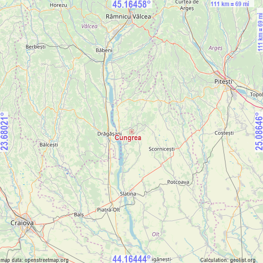
Cungrea GPS coordinates[2]
44° 40' 0.012" North, 24° 22' 59.988" East
| Map corner | latitude | longitude |
|---|---|---|
| Upper-left | 45.16458°, | 23.68021° |
| Center: | 44.66667°, | 24.38333° |
| Lower-right: | 44.16444°, | 25.08646° |
| Map W x H: | 111.2×111.2 km | = 69.1×69.1mi |
| max Lat: | 48.23793° ⇑81.1% North |
| Cungrea: | 44.66667° |
| min Lat: | ⇓18.9% South 43.65638° |
| min Long | Cungrea | max Long |
| 20.31667° | 24.38333° | 29.65403° |
| W 37.9%⇐ | ⇒62.1% E |
Elevation
Elevation of Cungrea is 211 m = 692 ft, and this is 43.9 m = 144 ft below average elevation for this country.
| Max E: |
1278 m = 4193 ft | 50.1% |
| Avg. | 254.9 m = 836 ft | |
| Cungrea | 211 m = 692 ft | |
Min E: |
-2 m = -7 ft | 49.9% |
See also: Romania elevation on elevation.city.
Geographical zone
Cungrea is located in North temperate zone (between Tropic of Cancer and the Arctic Circle). Distance of this Northern Tropic circle is 2360.5 km =1466.7 mi to South.| Distance of | km | miles | from Cungrea |
|---|---|---|---|
| North Pole | 5040.6 | 3132.1 | to North |
| Arctic Circle | 2434.7 | 1512.9 | to North |
| Tropic Cancer | 2360.5 | 1466.7 | to South |
| Equator | 4966.5 | 3086 | to South |


Nearby cities:
15 places around Cungrea: (largest is in red/bold)
• Albești
6.6 km =4.1 mi,  67°
67°
• Cornățelu
7.2 km =4.5 mi, 73°
• Călina
10.9 km =6.8 mi,  291°
291°
• Deleni
11.3 km =7 mi,  189°
189°
• Dienci
10.2 km =6.3 mi,  349°
349°
• Drăgăşani
9.4 km =5.8 mi,  258°
258°
• Dumitrești
5.6 km =3.5 mi, 289°
• Oporelu
7.9 km =4.9 mi,  160°
160°
• Poboru
9.2 km =5.7 mi,  90°
90°
• Poganu
5.2 km =3.2 mi, 262°
• Valea lui Alb
7.1 km =4.4 mi,  309°
309°
• Verguleasa
5.6 km =3.5 mi,  250°
250°
• Voiceşti
10.8 km =6.7 mi,  226°
226°
• Vultureşti
9.1 km =5.7 mi,  324°
324°
• Zlătărei
10.7 km =6.6 mi, 247°
Sources, notices
• [Note1] Compared only with cities in Romania existing in our database
• [Src1] Map data: © OpenStreetMap contributors (CC-BY-SA)
• [Src2] Other city data from geonames.org with taken over terms of usage.
• [Src3] Geographical zone / Annual Mean Temperature by Robert A. Rohde @ Wikipedia
