Cucuteni geodata
Cucuteni (Botoşani) is a populated place; located in Romania in Europe/Bucharest (GMT+3) time zone. With population of 851 people, there are 4834 cities with bigger population in this country. Compared to other cities in Romania, 96.2% of cities are located further ↓South; 85.8% of cities are located further ←West and 70.2% of cities have higher elevation than Cucuteni. Note1


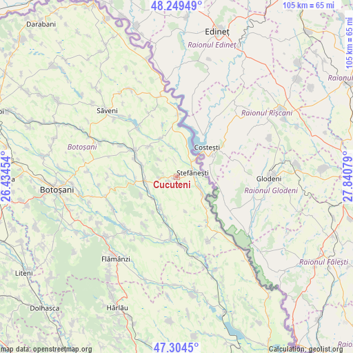
Cucuteni GPS coordinates[2]
47° 46' 44.904" North, 27° 8' 15.576" East
| Map corner | latitude | longitude |
|---|---|---|
| Upper-left | 48.24949°, | 26.43454° |
| Center: | 47.77914°, | 27.13766° |
| Lower-right: | 47.3045°, | 27.84079° |
| Map W x H: | 105.1×105.1 km | = 65.3×65.3mi |
| max Lat: | 48.23793° ⇑3.8% North |
| Cucuteni: | 47.77914° |
| min Lat: | ⇓96.2% South 43.65638° |
| min Long | Cucuteni | max Long |
| 20.31667° | 27.13766° | 29.65403° |
| W 85.8%⇐ | ⇒14.2% E |
Elevation
Elevation of Cucuteni is 126 m = 413 ft, and this is 128.9 m = 423 ft below average elevation for this country.
| Max E: |
1278 m = 4193 ft | 70.2% |
| Avg. | 254.9 m = 836 ft | |
| Cucuteni | 126 m = 413 ft | |
Min E: |
-2 m = -7 ft | 29.8% |
See also: Romania elevation on elevation.city.
Geographical zone
Cucuteni is located in North temperate zone (between Tropic of Cancer and the Arctic Circle). Distance of this North polar circle is 2088.6 km =1297.8 mi to North.| Distance of | km | miles | from Cucuteni |
|---|---|---|---|
| North Pole | 4694.5 | 2917 | to North |
| Arctic Circle | 2088.6 | 1297.8 | to North |
| Tropic Cancer | 2706.6 | 1681.8 | to South |
| Equator | 5312.5 | 3301 | to South |


Nearby cities:
15 places around Cucuteni: (largest is in red/bold)
• Albeşti
10.3 km =6.4 mi,  211°
211°
• Bobulești
7.4 km =4.6 mi,  114°
114°
• Buhăceni
11 km =6.8 mi,  289°
289°
• Băbiceni
5.5 km =3.4 mi,  239°
239°
• Bădiuți
5.3 km =3.3 mi,  84°
84°
• Dobârceni
6.7 km =4.2 mi,  308°
308°
• Durneşti
3.1 km =1.9 mi, 243°
• Guranda
5.2 km =3.2 mi,  267°
267°
• Ionășeni
12.1 km =7.5 mi, 243°
• Românești
9.3 km =5.8 mi,  124°
124°
• Stânca
7 km =4.3 mi,  46°
46°
• Truşeşti
9.1 km =5.7 mi,  261°
261°
• Tudor Vladimirescu
10.6 km =6.6 mi,  165°
165°
• Ştefăneşti-Sat
3.4 km =2.1 mi, 82°
• Ștefănești
4.9 km =3 mi,  73°
73°
Sources, notices
• [Note1] Compared only with cities in Romania existing in our database
• [Src1] Map data: © OpenStreetMap contributors (CC-BY-SA)
• [Src2] Other city data from geonames.org with taken over terms of usage.
• [Src3] Geographical zone / Annual Mean Temperature by Robert A. Rohde @ Wikipedia
