Cucuteni geodata
Cucuteni (Dâmboviţa) is a populated place; located in Romania in Europe/Bucharest (GMT+3) time zone. With population of 679 people, there are 5694 cities with bigger population in this country. Compared to other cities in Romania, 64.9% of cities are located further ↑North; 52.9% of cities are located further ←West and 92.7% of cities have lower elevation than Cucuteni. Note1


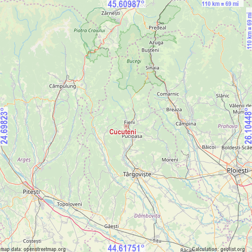
Cucuteni GPS coordinates[2]
45° 6' 57.06" North, 25° 24' 4.86" East
| Map corner | latitude | longitude |
|---|---|---|
| Upper-left | 45.60987°, | 24.69823° |
| Center: | 45.11585°, | 25.40135° |
| Lower-right: | 44.61751°, | 26.10448° |
| Map W x H: | 110.3×110.3 km | = 68.5×68.5mi |
| max Lat: | 48.23793° ⇑64.9% North |
| Cucuteni: | 45.11585° |
| min Lat: | ⇓35.1% South 43.65638° |
| min Long | Cucuteni | max Long |
| 20.31667° | 25.40135° | 29.65403° |
| W 52.9%⇐ | ⇒47.1% E |
Elevation
Elevation of Cucuteni is 563 m = 1847 ft, and this is 308.1 m = 1011 ft above average elevation for this country.
| Max E: |
1278 m = 4193 ft | 7.3% |
| Cucuteni | 563 m 1847 ft | |
| Avg. | 254.9 m = 836 ft | |
Min E: |
-2 m = -7 ft | 92.7% |
See also: Romania elevation on elevation.city.
Geographical zone
Cucuteni is located in North temperate zone (between Tropic of Cancer and the Arctic Circle). Distance of this North polar circle is 2384.8 km =1481.8 mi to North.| Distance of | km | miles | from Cucuteni |
|---|---|---|---|
| North Pole | 4990.6 | 3101 | to North |
| Arctic Circle | 2384.8 | 1481.8 | to North |
| Tropic Cancer | 2410.5 | 1497.8 | to South |
| Equator | 5016.4 | 3117 | to South |


Nearby cities:
15 places around Cucuteni: (largest is in red/bold)
• Bela
3.2 km =2 mi,  124°
124°
• Berevoești
1.7 km =1.1 mi,  84°
84°
• Buciumeni
5.4 km =3.4 mi,  45°
45°
• Bădeni
4.1 km =2.5 mi,  1°
1°
• Costești
3.4 km =2.1 mi,  345°
345°
• Dealu Mare
6.2 km =3.9 mi,  36°
36°
• Diaconești
4.8 km =3 mi, 121°
• Fieni
2.3 km =1.4 mi,  31°
31°
• Moțăieni
2.1 km =1.3 mi,  145°
145°
• Măgura
5.7 km =3.5 mi, 77°
• Piatra
5.7 km =3.5 mi,  355°
355°
• Pucioasa
4.9 km =3 mi, 149°
• Râu Alb de Jos
4.8 km =3 mi,  298°
298°
• Vulcana Băi
4.3 km =2.7 mi,  200°
200°
• Vulcana de Sus
3.8 km =2.4 mi,  244°
244°
Sources, notices
• [Note1] Compared only with cities in Romania existing in our database
• [Src1] Map data: © OpenStreetMap contributors (CC-BY-SA)
• [Src2] Other city data from geonames.org with taken over terms of usage.
• [Src3] Geographical zone / Annual Mean Temperature by Robert A. Rohde @ Wikipedia
