Pucioasa geodata
Pucioasa (Dâmboviţa) is a seat of a second-order administrative division; located in Romania in Europe/Bucharest (GMT+3) time zone. With population of 14,971 people, there are 134 cities with bigger population in this country. Compared to other cities in Romania, 66.6% of cities are located further ↑North; 53.4% of cities are located further ←West and 81.4% of cities have lower elevation than Pucioasa. Note1


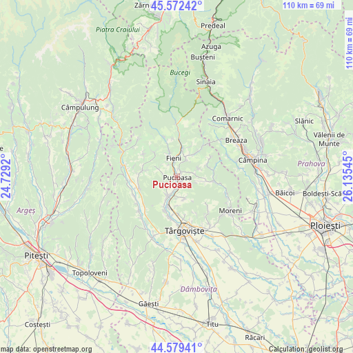
Pucioasa GPS coordinates[2]
45° 4' 41.052" North, 25° 25' 56.352" East
| Map corner | latitude | longitude |
|---|---|---|
| Upper-left | 45.57242°, | 24.7292° |
| Center: | 45.07807°, | 25.43232° |
| Lower-right: | 44.57941°, | 26.13545° |
| Map W x H: | 110.4×110.4 km | = 68.6×68.6mi |
| max Lat: | 48.23793° ⇑66.6% North |
| Pucioasa: | 45.07807° |
| min Lat: | ⇓33.4% South 43.65638° |
| min Long | Pucioasa | max Long |
| 20.31667° | 25.43232° | 29.65403° |
| W 53.4%⇐ | ⇒46.6% E |
Elevation
Elevation of Pucioasa is 407 m = 1335 ft, and this is 152.1 m = 499 ft above average elevation for this country.
| Max E: |
1278 m = 4193 ft | 18.6% |
| Pucioasa | 407 m 1335 ft | |
| Avg. | 254.9 m = 836 ft | |
Min E: |
-2 m = -7 ft | 81.4% |
See also: Romania elevation on elevation.city.
Geographical zone
Pucioasa is located in North temperate zone (between Tropic of Cancer and the Arctic Circle). Distance of this North polar circle is 2389 km =1484.5 mi to North.| Distance of | km | miles | from Pucioasa |
|---|---|---|---|
| North Pole | 4994.9 | 3103.7 | to North |
| Arctic Circle | 2389 | 1484.5 | to North |
| Tropic Cancer | 2406.3 | 1495.2 | to South |
| Equator | 5012.2 | 3114.4 | to South |


Nearby cities:
15 places around Pucioasa: (largest is in red/bold)
• Bela
2.4 km =1.5 mi,  5°
5°
• Berevoești
4.4 km =2.7 mi,  350°
350°
• Brăneşti
5.1 km =3.2 mi,  193°
193°
• Cucuteni
4.9 km =3 mi,  329°
329°
• Diaconești
2.3 km =1.4 mi,  45°
45°
• Fieni
6.3 km =3.9 mi, 348°
• Glodeni
2.3 km =1.4 mi,  134°
134°
• Lăculețe
6.6 km =4.1 mi,  180°
180°
• Moțăieni
2.7 km =1.7 mi, 333°
• Măgura
6.3 km =3.9 mi,  29°
29°
• Priboiu
5.8 km =3.6 mi, 187°
• Schela
6.3 km =3.9 mi,  147°
147°
• Toculești
6 km =3.7 mi,  208°
208°
• Vulcana Băi
3.9 km =2.4 mi,  272°
272°
• Vulcana de Sus
6.4 km =4 mi,  293°
293°
Sources, notices
• [Note1] Compared only with cities in Romania existing in our database
• [Src1] Map data: © OpenStreetMap contributors (CC-BY-SA)
• [Src2] Other city data from geonames.org with taken over terms of usage.
• [Src3] Geographical zone / Annual Mean Temperature by Robert A. Rohde @ Wikipedia
