Costești geodata
Costești (Dâmboviţa) is a populated place; located in Romania in Europe/Bucharest (GMT+3) time zone. With population of 891 people, there are 4654 cities with bigger population in this country. Compared to other cities in Romania, 63.7% of cities are located further ↑North; 52.6% of cities are located further ←West and 92.1% of cities have lower elevation than Costești. Note1


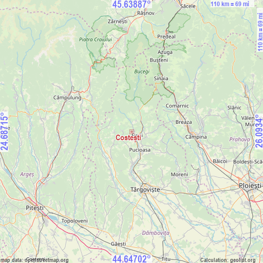
Costești GPS coordinates[2]
45° 8' 42.36" North, 25° 23' 24.972" East
| Map corner | latitude | longitude |
|---|---|---|
| Upper-left | 45.63887°, | 24.68715° |
| Center: | 45.1451°, | 25.39027° |
| Lower-right: | 44.64702°, | 26.0934° |
| Map W x H: | 110.3×110.3 km | = 68.5×68.5mi |
| max Lat: | 48.23793° ⇑63.7% North |
| Costești: | 45.1451° |
| min Lat: | ⇓36.3% South 43.65638° |
| min Long | Costești | max Long |
| 20.31667° | 25.39027° | 29.65403° |
| W 52.6%⇐ | ⇒47.4% E |
Elevation
Elevation of Costești is 551 m = 1808 ft, and this is 296.1 m = 971 ft above average elevation for this country.
| Max E: |
1278 m = 4193 ft | 7.9% |
| Costești | 551 m 1808 ft | |
| Avg. | 254.9 m = 836 ft | |
Min E: |
-2 m = -7 ft | 92.1% |
See also: Romania elevation on elevation.city.
Geographical zone
Costești is located in North temperate zone (between Tropic of Cancer and the Arctic Circle). Distance of this North polar circle is 2381.5 km =1479.8 mi to North.| Distance of | km | miles | from Costești |
|---|---|---|---|
| North Pole | 4987.4 | 3099 | to North |
| Arctic Circle | 2381.5 | 1479.8 | to North |
| Tropic Cancer | 2413.7 | 1499.8 | to South |
| Equator | 5019.7 | 3119.1 | to South |


Nearby cities:
15 places around Costești: (largest is in red/bold)
• Berevoești
4 km =2.5 mi,  139°
139°
• Buciumeni
4.7 km =2.9 mi,  83°
83°
• Bădeni
1.3 km =0.8 mi,  48°
48°
• Cucuteni
3.4 km =2.1 mi,  165°
165°
• Dealu Frumos
4.9 km =3 mi,  21°
21°
• Dealu Mare
4.9 km =3 mi,  69°
69°
• Ferestre
4.1 km =2.5 mi,  6°
6°
• Fieni
2.4 km =1.5 mi,  122°
122°
• Moțăieni
5.4 km =3.4 mi,  157°
157°
• Piatra
2.5 km =1.6 mi, 10°
• Pietroşiţa
5.4 km =3.4 mi,  38°
38°
• Runcu
4.3 km =2.7 mi,  352°
352°
• Râu Alb de Jos
3.5 km =2.2 mi,  254°
254°
• Râu Alb de Sus
5.3 km =3.3 mi,  288°
288°
• Siliștea
5.2 km =3.2 mi,  357°
357°
Sources, notices
• [Note1] Compared only with cities in Romania existing in our database
• [Src1] Map data: © OpenStreetMap contributors (CC-BY-SA)
• [Src2] Other city data from geonames.org with taken over terms of usage.
• [Src3] Geographical zone / Annual Mean Temperature by Robert A. Rohde @ Wikipedia
