Horia geodata
Horia (Constanța) is a seat of a second-order administrative division; located in Romania in Europe/Bucharest (GMT+3) time zone. With population of 1,249 people, there are 3637 cities with bigger population in this country. Compared to other cities in Romania, 82% of cities are located further ↑North; 97.3% of cities are located further ←West and 89.2% of cities have higher elevation than Horia. Note1


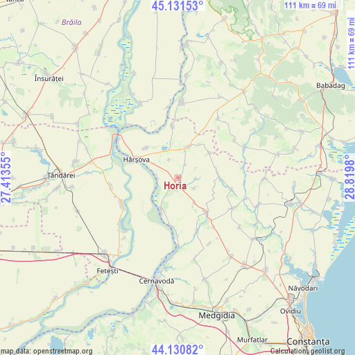
Horia GPS coordinates[2]
44° 37' 59.988" North, 28° 7' 0.012" East
| Map corner | latitude | longitude |
|---|---|---|
| Upper-left | 45.13153°, | 27.41355° |
| Center: | 44.63333°, | 28.11667° |
| Lower-right: | 44.13082°, | 28.8198° |
| Map W x H: | 111.3×111.3 km | = 69.2×69.2mi |
| max Lat: | 48.23793° ⇑82% North |
| Horia: | 44.63333° |
| min Lat: | ⇓18% South 43.65638° |
| min Long | Horia | max Long |
| 20.31667° | 28.11667° | 29.65403° |
| W 97.3%⇐ | ⇒2.7% E |
Elevation
Elevation of Horia is 62 m = 203 ft, and this is 192.9 m = 633 ft below average elevation for this country.
| Max E: |
1278 m = 4193 ft | 89.2% |
| Avg. | 254.9 m = 836 ft | |
| Horia | 62 m = 203 ft | |
Min E: |
-2 m = -7 ft | 10.8% |
See also: Romania elevation on elevation.city.
Geographical zone
Horia is located in North temperate zone (between Tropic of Cancer and the Arctic Circle). Distance of this Northern Tropic circle is 2356.8 km =1464.4 mi to South.| Distance of | km | miles | from Horia |
|---|---|---|---|
| North Pole | 5044.3 | 3134.4 | to North |
| Arctic Circle | 2438.4 | 1515.2 | to North |
| Tropic Cancer | 2356.8 | 1464.4 | to South |
| Equator | 4962.8 | 3083.7 | to South |


Nearby cities:
15 places around Horia: (largest is in red/bold)
• Băltăgești
17.8 km =11.1 mi,  159°
159°
• Ciobanu
13.9 km =8.6 mi,  312°
312°
• Crucea
14.5 km =9 mi,  140°
140°
• Dunărea
21.8 km =13.5 mi,  179°
179°
• Făcăeni
18.7 km =11.6 mi,  246°
246°
• Ghindăreşti
6.8 km =4.2 mi,  285°
285°
• Gârliciu
15.1 km =9.4 mi,  349°
349°
• Hârşova
14.4 km =8.9 mi, 293°
• Pantelimon
19.6 km =12.2 mi,  119°
119°
• Progresu
20.5 km =12.7 mi, 253°
• Saraiu
9.6 km =6 mi,  15°
15°
• Stupina
9.2 km =5.7 mi,  146°
146°
• Topalu
11.4 km =7.1 mi,  209°
209°
• Vlădeni
18.6 km =11.6 mi,  264°
264°
• Vulturu
12 km =7.5 mi,  81°
81°
Sources, notices
• [Note1] Compared only with cities in Romania existing in our database
• [Src1] Map data: © OpenStreetMap contributors (CC-BY-SA)
• [Src2] Other city data from geonames.org with taken over terms of usage.
• [Src3] Geographical zone / Annual Mean Temperature by Robert A. Rohde @ Wikipedia
