Crâmpotani geodata
Crâmpotani (Arges) is a populated place; located in Romania in Europe/Bucharest (GMT+3) time zone. With population of 613 people, there are 6117 cities with bigger population in this country. Compared to other cities in Romania, 69.4% of cities are located further ↑North; 57.2% of cities are located further →East and 74.1% of cities have lower elevation than Crâmpotani. Note1


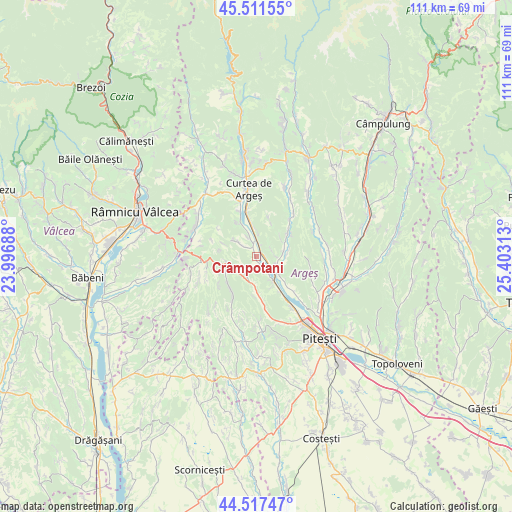
Crâmpotani GPS coordinates[2]
45° 1' 0.012" North, 24° 42' 0" East
| Map corner | latitude | longitude |
|---|---|---|
| Upper-left | 45.51155°, | 23.99688° |
| Center: | 45.01667°, | 24.7° |
| Lower-right: | 44.51747°, | 25.40313° |
| Map W x H: | 110.5×110.5 km | = 68.7×68.7mi |
| max Lat: | 48.23793° ⇑69.4% North |
| Crâmpotani: | 45.01667° |
| min Lat: | ⇓30.6% South 43.65638° |
| min Long | Crâmpotani | max Long |
| 20.31667° | 24.7° | 29.65403° |
| W 42.8%⇐ | ⇒57.2% E |
Elevation
Elevation of Crâmpotani is 347 m = 1138 ft, and this is 92.1 m = 302 ft above average elevation for this country.
| Max E: |
1278 m = 4193 ft | 25.9% |
| Crâmpotani | 347 m 1138 ft | |
| Avg. | 254.9 m = 836 ft | |
Min E: |
-2 m = -7 ft | 74.1% |
See also: Romania elevation on elevation.city.
Geographical zone
Crâmpotani is located in North temperate zone (between Tropic of Cancer and the Arctic Circle). Distance of this North polar circle is 2395.8 km =1488.7 mi to North.| Distance of | km | miles | from Crâmpotani |
|---|---|---|---|
| North Pole | 5001.7 | 3107.9 | to North |
| Arctic Circle | 2395.8 | 1488.7 | to North |
| Tropic Cancer | 2399.5 | 1491 | to South |
| Equator | 5005.4 | 3110.2 | to South |


Nearby cities:
15 places around Crâmpotani: (largest is in red/bold)
• Borlești
9.1 km =5.7 mi,  146°
146°
• Bunești
4.1 km =2.5 mi,  89°
89°
• Băiculeşti
5.6 km =3.5 mi,  0°
0°
• Calotești
6.1 km =3.8 mi,  127°
127°
• Cotmeana
8.6 km =5.3 mi,  229°
229°
• Drăganu-Olteni
9.4 km =5.8 mi,  171°
171°
• Dumbrăvești
6.1 km =3.8 mi,  186°
186°
• Merişani
6.4 km =4 mi, 147°
• Mănicești
1.3 km =0.8 mi,  64°
64°
• Toplița
8.6 km =5.3 mi,  17°
17°
• Tutana
4.8 km =3 mi,  307°
307°
• Valea Brazilor
4.3 km =2.7 mi,  340°
340°
• Valea lui Enache
8.6 km =5.3 mi,  329°
329°
• Zigoneni
8.5 km =5.3 mi,  349°
349°
• Zărnești
5.6 km =3.5 mi, 85°
Sources, notices
• [Note1] Compared only with cities in Romania existing in our database
• [Src1] Map data: © OpenStreetMap contributors (CC-BY-SA)
• [Src2] Other city data from geonames.org with taken over terms of usage.
• [Src3] Geographical zone / Annual Mean Temperature by Robert A. Rohde @ Wikipedia
