Băiculeşti geodata
Băiculeşti (Arges) is a seat of a second-order administrative division; located in Romania in Europe/Bucharest (GMT+3) time zone. With population of 6,207 people, there are 511 cities with bigger population in this country. Compared to other cities in Romania, 67.1% of cities are located further ↑North; 57.2% of cities are located further →East and 82.1% of cities have lower elevation than Băiculeşti. Note1


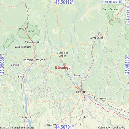
Băiculeşti GPS coordinates[2]
45° 4' 0.012" North, 24° 42' 0" East
| Map corner | latitude | longitude |
|---|---|---|
| Upper-left | 45.56112°, | 23.99688° |
| Center: | 45.06667°, | 24.7° |
| Lower-right: | 44.56791°, | 25.40313° |
| Map W x H: | 110.4×110.4 km | = 68.6×68.6mi |
| max Lat: | 48.23793° ⇑67.1% North |
| Băiculeşti: | 45.06667° |
| min Lat: | ⇓32.9% South 43.65638° |
| min Long | Băiculeşti | max Long |
| 20.31667° | 24.7° | 29.65403° |
| W 42.8%⇐ | ⇒57.2% E |
Elevation
Elevation of Băiculeşti is 413 m = 1355 ft, and this is 158.1 m = 519 ft above average elevation for this country.
| Max E: |
1278 m = 4193 ft | 17.9% |
| Băiculeşti | 413 m 1355 ft | |
| Avg. | 254.9 m = 836 ft | |
Min E: |
-2 m = -7 ft | 82.1% |
See also: Romania elevation on elevation.city.
Geographical zone
Băiculeşti is located in North temperate zone (between Tropic of Cancer and the Arctic Circle). Distance of this North polar circle is 2390.2 km =1485.2 mi to North.| Distance of | km | miles | from Băiculeşti |
|---|---|---|---|
| North Pole | 4996.1 | 3104.4 | to North |
| Arctic Circle | 2390.2 | 1485.2 | to North |
| Tropic Cancer | 2405 | 1494.4 | to South |
| Equator | 5010.9 | 3113.6 | to South |


Nearby cities:
15 places around Băiculeşti: (largest is in red/bold)
• Bunești
6.9 km =4.3 mi,  143°
143°
• Calotești
10.4 km =6.5 mi,  152°
152°
• Crâmpotani
5.6 km =3.5 mi,  180°
180°
• Curtea de Argeş
7.8 km =4.8 mi,  344°
344°
• Merişani
11.5 km =7.1 mi,  162°
162°
• Mălureni
8.7 km =5.4 mi,  64°
64°
• Mănicești
5.1 km =3.2 mi,  166°
166°
• Noapteș
5.5 km =3.4 mi,  317°
317°
• Stroești
10.2 km =6.3 mi,  46°
46°
• Toplița
3.6 km =2.2 mi,  44°
44°
• Tutana
4.7 km =2.9 mi,  235°
235°
• Valea Brazilor
2.1 km =1.3 mi,  223°
223°
• Valea lui Enache
4.7 km =2.9 mi,  292°
292°
• Zigoneni
3.2 km =2 mi,  330°
330°
• Zărnești
7.6 km =4.7 mi,  132°
132°
Sources, notices
• [Note1] Compared only with cities in Romania existing in our database
• [Src1] Map data: © OpenStreetMap contributors (CC-BY-SA)
• [Src2] Other city data from geonames.org with taken over terms of usage.
• [Src3] Geographical zone / Annual Mean Temperature by Robert A. Rohde @ Wikipedia
