Coza geodata
Coza (Vrancea) is a populated place; located in Romania in Europe/Bucharest (GMT+3) time zone. With population of 982 people, there are 4348 cities with bigger population in this country. Compared to other cities in Romania, 52.9% of cities are located further ↓South; 76.1% of cities are located further ←West and 84.1% of cities have lower elevation than Coza. Note1


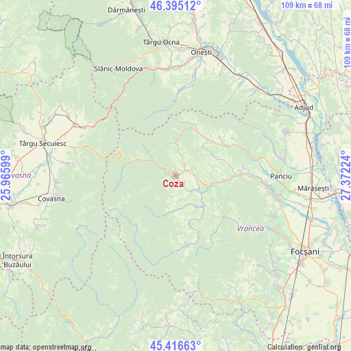
Coza GPS coordinates[2]
45° 54' 28.908" North, 26° 40' 8.796" East
| Map corner | latitude | longitude |
|---|---|---|
| Upper-left | 46.39512°, | 25.96599° |
| Center: | 45.90803°, | 26.66911° |
| Lower-right: | 45.41663°, | 27.37224° |
| Map W x H: | 108.8×108.8 km | = 67.6×67.6mi |
| max Lat: | 48.23793° ⇑47.1% North |
| Coza: | 45.90803° |
| min Lat: | ⇓52.9% South 43.65638° |
| min Long | Coza | max Long |
| 20.31667° | 26.66911° | 29.65403° |
| W 76.1%⇐ | ⇒23.9% E |
Elevation
Elevation of Coza is 436 m = 1430 ft, and this is 181.1 m = 594 ft above average elevation for this country.
| Max E: |
1278 m = 4193 ft | 15.9% |
| Coza | 436 m 1430 ft | |
| Avg. | 254.9 m = 836 ft | |
Min E: |
-2 m = -7 ft | 84.1% |
See also: Romania elevation on elevation.city.
Geographical zone
Coza is located in North temperate zone (between Tropic of Cancer and the Arctic Circle). Distance of this North polar circle is 2296.7 km =1427.1 mi to North.| Distance of | km | miles | from Coza |
|---|---|---|---|
| North Pole | 4902.6 | 3046.3 | to North |
| Arctic Circle | 2296.7 | 1427.1 | to North |
| Tropic Cancer | 2498.6 | 1552.6 | to South |
| Equator | 5104.5 | 3171.8 | to South |


Nearby cities:
15 places around Coza: (largest is in red/bold)
• Bârseşti
5.1 km =3.2 mi,  79°
79°
• Dragosloveni
10.2 km =6.3 mi,  358°
358°
• Hăulișca
3.1 km =1.9 mi,  156°
156°
• Mătăcina
10.5 km =6.5 mi,  105°
105°
• Negrilești
4.3 km =2.7 mi,  41°
41°
• Nistoreşti
9.7 km =6 mi,  149°
149°
• Poiana
7.8 km =4.8 mi,  117°
117°
• Păulești
2.4 km =1.5 mi,  139°
139°
• Rucăreni
9.7 km =6 mi,  353°
353°
• Spinești
3.3 km =2.1 mi, 121°
• Topești
6.5 km =4 mi,  92°
92°
• Tulnici
1 km =0.6 mi, 348°
• Valea Sării
10.6 km =6.6 mi, 109°
• Viișoara
12 km =7.5 mi, 83°
• Vrâncioaia
8.1 km =5 mi, 142°
Sources, notices
• [Note1] Compared only with cities in Romania existing in our database
• [Src1] Map data: © OpenStreetMap contributors (CC-BY-SA)
• [Src2] Other city data from geonames.org with taken over terms of usage.
• [Src3] Geographical zone / Annual Mean Temperature by Robert A. Rohde @ Wikipedia
