Cotiglet geodata
Cotiglet (Bihor) is a populated place; located in Romania in Europe/Bucharest (GMT+3) time zone. With population of 594 people, there are 6243 cities with bigger population in this country. Compared to other cities in Romania, 76.2% of cities are located further ↓South; 92.8% of cities are located further →East and 54.6% of cities have higher elevation than Cotiglet. Note1


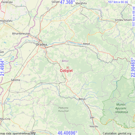
Cotiglet GPS coordinates[2]
46° 53' 22.668" North, 22° 12' 5.472" East
| Map corner | latitude | longitude |
|---|---|---|
| Upper-left | 47.368°, | 21.4984° |
| Center: | 46.88963°, | 22.20152° |
| Lower-right: | 46.40696°, | 22.90465° |
| Map W x H: | 106.9×106.9 km | = 66.4×66.4mi |
| max Lat: | 48.23793° ⇑23.8% North |
| Cotiglet: | 46.88963° |
| min Lat: | ⇓76.2% South 43.65638° |
| min Long | Cotiglet | max Long |
| 20.31667° | 22.20152° | 29.65403° |
| W 7.2%⇐ | ⇒92.8% E |
Elevation
Elevation of Cotiglet is 189 m = 620 ft, and this is 65.9 m = 216 ft below average elevation for this country.
| Max E: |
1278 m = 4193 ft | 54.6% |
| Avg. | 254.9 m = 836 ft | |
| Cotiglet | 189 m = 620 ft | |
Min E: |
-2 m = -7 ft | 45.4% |
See also: Romania elevation on elevation.city.
Geographical zone
Cotiglet is located in North temperate zone (between Tropic of Cancer and the Arctic Circle). Distance of this North polar circle is 2187.5 km =1359.2 mi to North.| Distance of | km | miles | from Cotiglet |
|---|---|---|---|
| North Pole | 4793.4 | 2978.5 | to North |
| Arctic Circle | 2187.5 | 1359.2 | to North |
| Tropic Cancer | 2607.7 | 1620.3 | to South |
| Equator | 5213.6 | 3239.6 | to South |


Nearby cities:
15 places around Cotiglet: (largest is in red/bold)
• Bucuroaia
4.5 km =2.8 mi,  343°
343°
• Calea Mare
10.4 km =6.5 mi,  282°
282°
• Ceica
4.6 km =2.9 mi,  197°
197°
• Ceișoara
3.7 km =2.3 mi,  178°
178°
• Corbești
2.7 km =1.7 mi,  95°
95°
• Dobreşti
8.7 km =5.4 mi,  120°
120°
• Drăgeşti
5.2 km =3.2 mi,  262°
262°
• Dușești
6.1 km =3.8 mi, 196°
• Hidișel
7.5 km =4.7 mi,  144°
144°
• Lăzăreni
10.6 km =6.6 mi, 256°
• Surduc
9.6 km =6 mi,  0°
0°
• Sâmbăta
9.8 km =6.1 mi, 179°
• Topa de Sus
4.7 km =2.9 mi,  126°
126°
• Tășad
7.9 km =4.9 mi,  312°
312°
• Șerghiș
10.5 km =6.5 mi,  16°
16°
Sources, notices
• [Note1] Compared only with cities in Romania existing in our database
• [Src1] Map data: © OpenStreetMap contributors (CC-BY-SA)
• [Src2] Other city data from geonames.org with taken over terms of usage.
• [Src3] Geographical zone / Annual Mean Temperature by Robert A. Rohde @ Wikipedia
