Lăzăreni geodata
Lăzăreni (Bihor) is a seat of a second-order administrative division; located in Romania in Europe/Bucharest (GMT+3) time zone. With population of 2,982 people, there are 1782 cities with bigger population in this country. Compared to other cities in Romania, 75.7% of cities are located further ↓South; 93.9% of cities are located further →East and 65.7% of cities have lower elevation than Lăzăreni. Note1


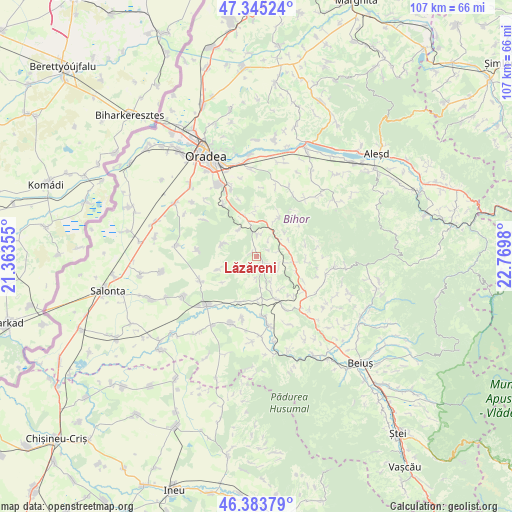
Lăzăreni GPS coordinates[2]
46° 52' 0.012" North, 22° 4' 0.012" East
| Map corner | latitude | longitude |
|---|---|---|
| Upper-left | 47.34524°, | 21.36355° |
| Center: | 46.86667°, | 22.06667° |
| Lower-right: | 46.38379°, | 22.7698° |
| Map W x H: | 106.9×106.9 km | = 66.4×66.4mi |
| max Lat: | 48.23793° ⇑24.3% North |
| Lăzăreni: | 46.86667° |
| min Lat: | ⇓75.7% South 43.65638° |
| min Long | Lăzăreni | max Long |
| 20.31667° | 22.06667° | 29.65403° |
| W 6.1%⇐ | ⇒93.9% E |
Elevation
Elevation of Lăzăreni is 294 m = 965 ft, and this is 39.1 m = 128 ft above average elevation for this country.
| Max E: |
1278 m = 4193 ft | 34.3% |
| Lăzăreni | 294 m 965 ft | |
| Avg. | 254.9 m = 836 ft | |
Min E: |
-2 m = -7 ft | 65.7% |
See also: Romania elevation on elevation.city.
Geographical zone
Lăzăreni is located in North temperate zone (between Tropic of Cancer and the Arctic Circle). Distance of this North polar circle is 2190.1 km =1360.9 mi to North.| Distance of | km | miles | from Lăzăreni |
|---|---|---|---|
| North Pole | 4796 | 2980.1 | to North |
| Arctic Circle | 2190.1 | 1360.9 | to North |
| Tropic Cancer | 2605.2 | 1618.8 | to South |
| Equator | 5211.1 | 3238 | to South |


Nearby cities:
15 places around Lăzăreni: (largest is in red/bold)
• Calea Mare
4.8 km =3 mi,  1°
1°
• Ceica
9.1 km =5.7 mi,  101°
101°
• Ceișoara
10.4 km =6.5 mi, 96°
• Cordău
11.2 km =7 mi,  325°
325°
• Cotiglet
10.6 km =6.6 mi,  76°
76°
• Drăgeşti
5.4 km =3.4 mi,  69°
69°
• Dumbrava
9 km =5.6 mi,  178°
178°
• Dușești
9.2 km =5.7 mi,  111°
111°
• Gepiș
4.2 km =2.6 mi,  236°
236°
• Hidişelu de Sus
9.4 km =5.8 mi,  352°
352°
• Holod
10.6 km =6.6 mi,  151°
151°
• Lupoaia
8.4 km =5.2 mi, 146°
• Mierlău
6.7 km =4.2 mi,  324°
324°
• Râpa
9.9 km =6.2 mi,  198°
198°
• Tășad
9.1 km =5.7 mi,  29°
29°
Sources, notices
• [Note1] Compared only with cities in Romania existing in our database
• [Src1] Map data: © OpenStreetMap contributors (CC-BY-SA)
• [Src2] Other city data from geonames.org with taken over terms of usage.
• [Src3] Geographical zone / Annual Mean Temperature by Robert A. Rohde @ Wikipedia
