Ferestre geodata
Ferestre (Dâmboviţa) is a populated place; located in Romania in Europe/Bucharest (GMT+3) time zone. With population of 560 people, there are 6501 cities with bigger population in this country. Compared to other cities in Romania, 62.5% of cities are located further ↑North; 52.7% of cities are located further ←West and 94% of cities have lower elevation than Ferestre. Note1


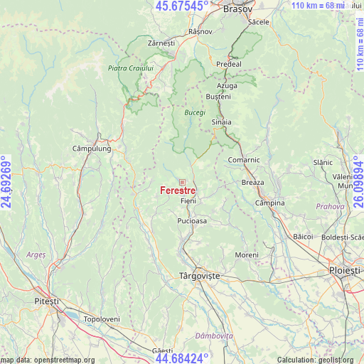
Ferestre GPS coordinates[2]
45° 10' 55.2" North, 25° 23' 44.916" East
| Map corner | latitude | longitude |
|---|---|---|
| Upper-left | 45.67545°, | 24.69269° |
| Center: | 45.182°, | 25.39581° |
| Lower-right: | 44.68424°, | 26.09894° |
| Map W x H: | 110.2×110.2 km | = 68.5×68.5mi |
| max Lat: | 48.23793° ⇑62.5% North |
| Ferestre: | 45.182° |
| min Lat: | ⇓37.5% South 43.65638° |
| min Long | Ferestre | max Long |
| 20.31667° | 25.39581° | 29.65403° |
| W 52.7%⇐ | ⇒47.3% E |
Elevation
Elevation of Ferestre is 598 m = 1962 ft, and this is 343.1 m = 1126 ft above average elevation for this country.
| Max E: |
1278 m = 4193 ft | 6% |
| Ferestre | 598 m 1962 ft | |
| Avg. | 254.9 m = 836 ft | |
Min E: |
-2 m = -7 ft | 94% |
See also: Romania elevation on elevation.city.
Geographical zone
Ferestre is located in North temperate zone (between Tropic of Cancer and the Arctic Circle). Distance of this North polar circle is 2377.4 km =1477.2 mi to North.| Distance of | km | miles | from Ferestre |
|---|---|---|---|
| North Pole | 4983.3 | 3096.5 | to North |
| Arctic Circle | 2377.4 | 1477.2 | to North |
| Tropic Cancer | 2417.8 | 1502.4 | to South |
| Equator | 5023.8 | 3121.6 | to South |


Nearby cities:
15 places around Ferestre: (largest is in red/bold)
• Brebu
4.3 km =2.7 mi,  282°
282°
• Buciumeni
5.5 km =3.4 mi,  129°
129°
• Bădeni
3.3 km =2.1 mi,  170°
170°
• Costești
4.1 km =2.5 mi,  186°
186°
• Dealu Frumos
1.4 km =0.9 mi,  73°
73°
• Dealu Mare
4.8 km =3 mi,  119°
119°
• Fieni
5.7 km =3.5 mi,  163°
163°
• Lunca
4.3 km =2.7 mi,  61°
61°
• Moroeni
4.8 km =3 mi,  37°
37°
• Piatra
1.7 km =1.1 mi,  179°
179°
• Pietroşiţa
2.9 km =1.8 mi,  87°
87°
• Pucheni
5.8 km =3.6 mi,  30°
30°
• Runcu
1 km =0.6 mi, 278°
• Râu Alb de Sus
5.9 km =3.7 mi,  246°
246°
• Siliștea
1.2 km =0.7 mi,  329°
329°
Sources, notices
• [Note1] Compared only with cities in Romania existing in our database
• [Src1] Map data: © OpenStreetMap contributors (CC-BY-SA)
• [Src2] Other city data from geonames.org with taken over terms of usage.
• [Src3] Geographical zone / Annual Mean Temperature by Robert A. Rohde @ Wikipedia
