Coșnea geodata
Coșnea (Bacău) is a populated place; located in Romania in Europe/Bucharest (GMT+3) time zone. With population of 643 people, there are 5921 cities with bigger population in this country. Compared to other cities in Romania, 65.3% of cities are located further ↓South; 64.6% of cities are located further ←West and 99.4% of cities have lower elevation than Coșnea. Note1


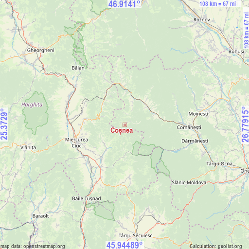
Coșnea GPS coordinates[2]
46° 25' 53.94" North, 26° 4' 33.672" East
| Map corner | latitude | longitude |
|---|---|---|
| Upper-left | 46.9141°, | 25.3729° |
| Center: | 46.43165°, | 26.07602° |
| Lower-right: | 45.94489°, | 26.77915° |
| Map W x H: | 107.8×107.8 km | = 67×67mi |
| max Lat: | 48.23793° ⇑34.7% North |
| Coșnea: | 46.43165° |
| min Lat: | ⇓65.3% South 43.65638° |
| min Long | Coșnea | max Long |
| 20.31667° | 26.07602° | 29.65403° |
| W 64.6%⇐ | ⇒35.4% E |
Elevation
Elevation of Coșnea is 909 m = 2982 ft, and this is 654.1 m = 2146 ft above average elevation for this country.
| Max E: |
1278 m = 4193 ft | 0.59999999999999% |
| Coșnea | 909 m 2982 ft | |
| Avg. | 254.9 m = 836 ft | |
Min E: |
-2 m = -7 ft | 99.4% |
See also: Romania elevation on elevation.city.
Geographical zone
Coșnea is located in North temperate zone (between Tropic of Cancer and the Arctic Circle). Distance of this North polar circle is 2238.5 km =1390.9 mi to North.| Distance of | km | miles | from Coșnea |
|---|---|---|---|
| North Pole | 4844.3 | 3010.1 | to North |
| Arctic Circle | 2238.5 | 1390.9 | to North |
| Tropic Cancer | 2556.8 | 1588.7 | to South |
| Equator | 5162.7 | 3208 | to South |


Nearby cities:
15 places around Coșnea: (largest is in red/bold)
• Agăş
12.2 km =7.6 mi,  61°
61°
• Armășeni
12.4 km =7.7 mi,  225°
225°
• Brusturoasa
13.4 km =8.3 mi,  45°
45°
• Camenca
13.4 km =8.3 mi, 45°
• Ciugheș
10.6 km =6.6 mi,  18°
18°
• Cotumba
11.5 km =7.1 mi, 50°
• Ghimeș
15.2 km =9.4 mi,  3°
3°
• Izvorul Trotușului
11.8 km =7.3 mi,  299°
299°
• Lunca de Sus
14.1 km =8.8 mi,  323°
323°
• Palanca
11.7 km =7.3 mi, 15°
• Popoiu
12.7 km =7.9 mi,  14°
14°
• Preluci
15.6 km =9.7 mi,  79°
79°
• Păltiniș-Ciuc
15 km =9.3 mi,  326°
326°
• Sulța
13.1 km =8.1 mi,  71°
71°
• Valea Ugra
12.9 km =8 mi, 323°
Sources, notices
• [Note1] Compared only with cities in Romania existing in our database
• [Src1] Map data: © OpenStreetMap contributors (CC-BY-SA)
• [Src2] Other city data from geonames.org with taken over terms of usage.
• [Src3] Geographical zone / Annual Mean Temperature by Robert A. Rohde @ Wikipedia
