Comanda geodata
Comanda (Mehedinţi) is a section of populated place; located in Romania in Europe/Bucharest (GMT+3) time zone. With population of 1,384 people, there are 3368 cities with bigger population in this country. Compared to other cities in Romania, 81.6% of cities are located further ↑North; 82.1% of cities are located further →East and 57.7% of cities have higher elevation than Comanda. Note1


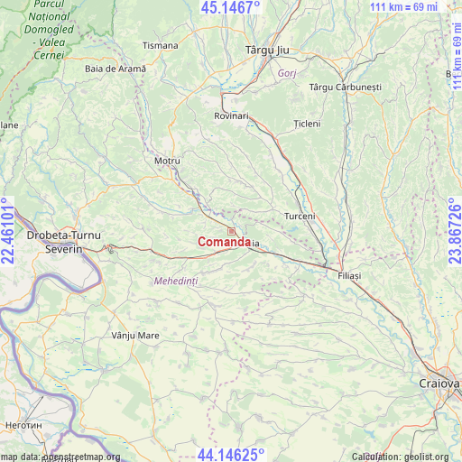
Comanda GPS coordinates[2]
44° 38' 55.068" North, 23° 9' 50.868" East
| Map corner | latitude | longitude |
|---|---|---|
| Upper-left | 45.1467°, | 22.46101° |
| Center: | 44.64863°, | 23.16413° |
| Lower-right: | 44.14625°, | 23.86726° |
| Map W x H: | 111.2×111.2 km | = 69.1×69.1mi |
| max Lat: | 48.23793° ⇑81.6% North |
| Comanda: | 44.64863° |
| min Lat: | ⇓18.4% South 43.65638° |
| min Long | Comanda | max Long |
| 20.31667° | 23.16413° | 29.65403° |
| W 17.9%⇐ | ⇒82.1% E |
Elevation
Elevation of Comanda is 175 m = 574 ft, and this is 79.9 m = 262 ft below average elevation for this country.
| Max E: |
1278 m = 4193 ft | 57.7% |
| Avg. | 254.9 m = 836 ft | |
| Comanda | 175 m = 574 ft | |
Min E: |
-2 m = -7 ft | 42.3% |
See also: Romania elevation on elevation.city.
Geographical zone
Comanda is located in North temperate zone (between Tropic of Cancer and the Arctic Circle). Distance of this Northern Tropic circle is 2358.5 km =1465.5 mi to South.| Distance of | km | miles | from Comanda |
|---|---|---|---|
| North Pole | 5042.6 | 3133.3 | to North |
| Arctic Circle | 2436.7 | 1514.1 | to North |
| Tropic Cancer | 2358.5 | 1465.5 | to South |
| Equator | 4964.5 | 3084.8 | to South |


Nearby cities:
15 places around Comanda: (largest is in red/bold)
• Brezniţa-Motru
10 km =6.2 mi,  155°
155°
• Ciochiuța
6.3 km =3.9 mi,  216°
216°
• Cordun
10.4 km =6.5 mi,  294°
294°
• Cotoroaia
10.3 km =6.4 mi,  270°
270°
• Covrigi
10 km =6.2 mi,  353°
353°
• Cârceni
7.8 km =4.8 mi,  77°
77°
• Jirov
6.6 km =4.1 mi, 292°
• Lunca Banului
7.5 km =4.7 mi,  120°
120°
• Menții din Dos
6.8 km =4.2 mi,  43°
43°
• Miluta
6.1 km =3.8 mi,  6°
6°
• Ohaba Jiu
10.3 km =6.4 mi, 39°
• Strehaia
4.5 km =2.8 mi,  141°
141°
• Valea
8.8 km =5.5 mi,  20°
20°
• Voloiac
6.2 km =3.9 mi,  234°
234°
• Văgiuleşti
9.9 km =6.2 mi,  319°
319°
Sources, notices
• [Note1] Compared only with cities in Romania existing in our database
• [Src1] Map data: © OpenStreetMap contributors (CC-BY-SA)
• [Src2] Other city data from geonames.org with taken over terms of usage.
• [Src3] Geographical zone / Annual Mean Temperature by Robert A. Rohde @ Wikipedia
