Voloiac geodata
Voloiac (Mehedinţi) is a seat of a second-order administrative division; located in Romania in Europe/Bucharest (GMT+3) time zone. With population of 472 people, there are 7023 cities with bigger population in this country. Compared to other cities in Romania, 82.4% of cities are located further ↑North; 83% of cities are located further →East and 55.2% of cities have lower elevation than Voloiac. Note1


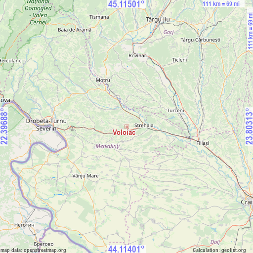
Voloiac GPS coordinates[2]
44° 37' 0.012" North, 23° 6' 0" East
| Map corner | latitude | longitude |
|---|---|---|
| Upper-left | 45.11501°, | 22.39688° |
| Center: | 44.61667°, | 23.1° |
| Lower-right: | 44.11401°, | 23.80313° |
| Map W x H: | 111.3×111.3 km | = 69.2×69.2mi |
| max Lat: | 48.23793° ⇑82.4% North |
| Voloiac: | 44.61667° |
| min Lat: | ⇓17.6% South 43.65638° |
| min Long | Voloiac | max Long |
| 20.31667° | 23.1° | 29.65403° |
| W 17%⇐ | ⇒83% E |
Elevation
Elevation of Voloiac is 239 m = 784 ft, and this is 15.9 m = 52 ft below average elevation for this country.
| Max E: |
1278 m = 4193 ft | 44.8% |
| Avg. | 254.9 m = 836 ft | |
| Voloiac | 239 m = 784 ft | |
Min E: |
-2 m = -7 ft | 55.2% |
See also: Romania elevation on elevation.city.
Geographical zone
Voloiac is located in North temperate zone (between Tropic of Cancer and the Arctic Circle). Distance of this Northern Tropic circle is 2355 km =1463.3 mi to South.| Distance of | km | miles | from Voloiac |
|---|---|---|---|
| North Pole | 5046.2 | 3135.6 | to North |
| Arctic Circle | 2440.3 | 1516.3 | to North |
| Tropic Cancer | 2355 | 1463.3 | to South |
| Equator | 4960.9 | 3082.6 | to South |


Nearby cities:
15 places around Voloiac: (largest is in red/bold)
• Brezniţa-Motru
10.8 km =6.7 mi,  121°
121°
• Ciochiuța
2 km =1.2 mi,  138°
138°
• Comanda
6.2 km =3.9 mi,  54°
54°
• Corcova
10.1 km =6.3 mi,  336°
336°
• Cordun
8.9 km =5.5 mi,  330°
330°
• Cotoroaia
6.4 km =4 mi,  304°
304°
• Dumbrava de Sus
11.2 km =7 mi,  173°
173°
• Greci
7.5 km =4.7 mi, 169°
• Jirov
6.1 km =3.8 mi,  350°
350°
• Lunca Banului
11.5 km =7.1 mi,  91°
91°
• Miluta
11.3 km =7 mi,  30°
30°
• Strehaia
7.9 km =4.9 mi, 90°
• Tâmna
8.6 km =5.3 mi,  229°
229°
• Valea Ursului
4.6 km =2.9 mi, 229°
• Văgiuleşti
11.2 km =7 mi, 353°
Sources, notices
• [Note1] Compared only with cities in Romania existing in our database
• [Src1] Map data: © OpenStreetMap contributors (CC-BY-SA)
• [Src2] Other city data from geonames.org with taken over terms of usage.
• [Src3] Geographical zone / Annual Mean Temperature by Robert A. Rohde @ Wikipedia
