Colibași geodata
Colibași (Olt) is a populated place; located in Romania in Europe/Bucharest (GMT+3) time zone. With population of 605 people, there are 6169 cities with bigger population in this country. Compared to other cities in Romania, 85.1% of cities are located further ↑North; 64.4% of cities are located further →East and 71.2% of cities have higher elevation than Colibași. Note1


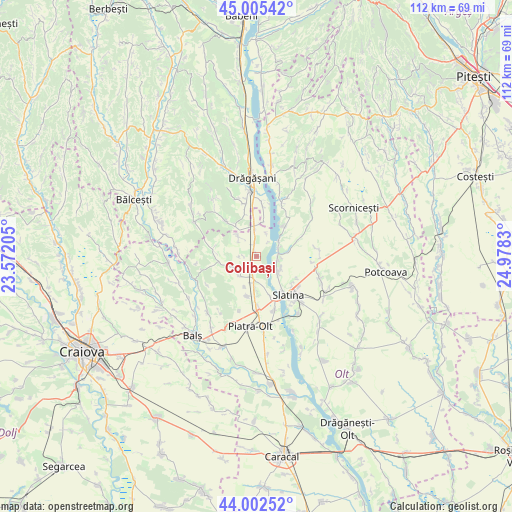
Colibași GPS coordinates[2]
44° 30' 22.068" North, 24° 16' 30.612" East
| Map corner | latitude | longitude |
|---|---|---|
| Upper-left | 45.00542°, | 23.57205° |
| Center: | 44.50613°, | 24.27517° |
| Lower-right: | 44.00252°, | 24.9783° |
| Map W x H: | 111.5×111.5 km | = 69.3×69.3mi |
| max Lat: | 48.23793° ⇑85.1% North |
| Colibași: | 44.50613° |
| min Lat: | ⇓14.9% South 43.65638° |
| min Long | Colibași | max Long |
| 20.31667° | 24.27517° | 29.65403° |
| W 35.6%⇐ | ⇒64.4% E |
Elevation
Elevation of Colibași is 123 m = 404 ft, and this is 131.9 m = 433 ft below average elevation for this country.
| Max E: |
1278 m = 4193 ft | 71.2% |
| Avg. | 254.9 m = 836 ft | |
| Colibași | 123 m = 404 ft | |
Min E: |
-2 m = -7 ft | 28.8% |
See also: Romania elevation on elevation.city.
Geographical zone
Colibași is located in North temperate zone (between Tropic of Cancer and the Arctic Circle). Distance of this Northern Tropic circle is 2342.7 km =1455.7 mi to South.| Distance of | km | miles | from Colibași |
|---|---|---|---|
| North Pole | 5058.4 | 3143.1 | to North |
| Arctic Circle | 2452.6 | 1524 | to North |
| Tropic Cancer | 2342.7 | 1455.7 | to South |
| Equator | 4948.6 | 3074.9 | to South |


Nearby cities:
15 places around Colibași: (largest is in red/bold)
• Arcești
5.5 km =3.4 mi,  216°
216°
• Arcești Cot
5.4 km =3.4 mi,  184°
184°
• Cocorăști
5.5 km =3.4 mi,  244°
244°
• Curtişoara
4.7 km =2.9 mi,  98°
98°
• Doba
3.3 km =2.1 mi,  229°
229°
• Dobrotinet
6.4 km =4 mi,  117°
117°
• Grădinari
6.8 km =4.2 mi,  354°
354°
• Linia din Vale
6.6 km =4.1 mi,  128°
128°
• Pietrișu
6.2 km =3.9 mi,  112°
112°
• Pleşoiu
4.4 km =2.7 mi,  188°
188°
• Proaspeți
7.1 km =4.4 mi,  136°
136°
• Runcu Mare
5.6 km =3.5 mi,  355°
355°
• Strejeşti
3.1 km =1.9 mi, 347°
• Strejeștii de Sus
5.6 km =3.5 mi,  318°
318°
• Teslui
7.3 km =4.5 mi,  80°
80°
Sources, notices
• [Note1] Compared only with cities in Romania existing in our database
• [Src1] Map data: © OpenStreetMap contributors (CC-BY-SA)
• [Src2] Other city data from geonames.org with taken over terms of usage.
• [Src3] Geographical zone / Annual Mean Temperature by Robert A. Rohde @ Wikipedia
