Chiribiș geodata
Chiribiș (Bihor) is a populated place; located in Romania in Europe/Bucharest (GMT+3) time zone. With population of 778 people, there are 5156 cities with bigger population in this country. Compared to other cities in Romania, 86.8% of cities are located further ↓South; 91.2% of cities are located further →East and 68.1% of cities have higher elevation than Chiribiș. Note1


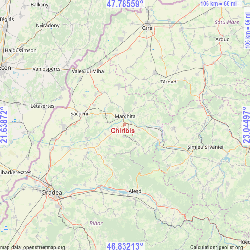
Chiribiș GPS coordinates[2]
47° 18' 39.636" North, 22° 20' 30.624" East
| Map corner | latitude | longitude |
|---|---|---|
| Upper-left | 47.78559°, | 21.63872° |
| Center: | 47.31101°, | 22.34184° |
| Lower-right: | 46.83213°, | 23.04497° |
| Map W x H: | 106×106 km | = 65.9×65.9mi |
| max Lat: | 48.23793° ⇑13.2% North |
| Chiribiș: | 47.31101° |
| min Lat: | ⇓86.8% South 43.65638° |
| min Long | Chiribiș | max Long |
| 20.31667° | 22.34184° | 29.65403° |
| W 8.8%⇐ | ⇒91.2% E |
Elevation
Elevation of Chiribiș is 134 m = 440 ft, and this is 120.9 m = 397 ft below average elevation for this country.
| Max E: |
1278 m = 4193 ft | 68.1% |
| Avg. | 254.9 m = 836 ft | |
| Chiribiș | 134 m = 440 ft | |
Min E: |
-2 m = -7 ft | 31.9% |
See also: Romania elevation on elevation.city.
Geographical zone
Chiribiș is located in North temperate zone (between Tropic of Cancer and the Arctic Circle). Distance of this North polar circle is 2140.7 km =1330.2 mi to North.| Distance of | km | miles | from Chiribiș |
|---|---|---|---|
| North Pole | 4746.6 | 2949.4 | to North |
| Arctic Circle | 2140.7 | 1330.2 | to North |
| Tropic Cancer | 2654.6 | 1649.5 | to South |
| Equator | 5260.5 | 3268.7 | to South |


Nearby cities:
15 places around Chiribiș: (largest is in red/bold)
• Abram
3.2 km =2 mi,  78°
78°
• Abrămuţ
7 km =4.3 mi,  275°
275°
• Bistra
8.7 km =5.4 mi,  135°
135°
• Bogei
5.3 km =3.3 mi,  164°
164°
• Chiraleu
3.3 km =2.1 mi,  259°
259°
• Chişlaz
8.7 km =5.4 mi,  249°
249°
• Ciutelec
6.4 km =4 mi,  148°
148°
• Ghenetea
9.6 km =6 mi,  25°
25°
• Marghita
4.4 km =2.7 mi,  351°
351°
• Margine
6.5 km =4 mi,  106°
106°
• Mișca
8.2 km =5.1 mi,  229°
229°
• Petreu
4.5 km =2.8 mi,  310°
310°
• Suiug
6.9 km =4.3 mi, 81°
• Săldăbagiu de Barcău
9.2 km =5.7 mi,  96°
96°
• Tăuteu
5 km =3.1 mi,  187°
187°
Sources, notices
• [Note1] Compared only with cities in Romania existing in our database
• [Src1] Map data: © OpenStreetMap contributors (CC-BY-SA)
• [Src2] Other city data from geonames.org with taken over terms of usage.
• [Src3] Geographical zone / Annual Mean Temperature by Robert A. Rohde @ Wikipedia
