Cheia geodata
Cheia (Vâlcea) is a section of populated place; located in Romania in Europe/Bucharest (GMT+3) time zone. With population of 1,097 people, there are 3998 cities with bigger population in this country. Compared to other cities in Romania, 62.5% of cities are located further ↑North; 65.7% of cities are located further →East and 87% of cities have lower elevation than Cheia. Note1


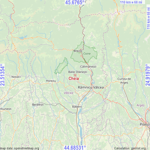
Cheia GPS coordinates[2]
45° 10' 59.016" North, 24° 12' 59.976" East
| Map corner | latitude | longitude |
|---|---|---|
| Upper-left | 45.6765°, | 23.51354° |
| Center: | 45.18306°, | 24.21666° |
| Lower-right: | 44.68531°, | 24.91979° |
| Map W x H: | 110.2×110.2 km | = 68.5×68.5mi |
| max Lat: | 48.23793° ⇑62.5% North |
| Cheia: | 45.18306° |
| min Lat: | ⇓37.5% South 43.65638° |
| min Long | Cheia | max Long |
| 20.31667° | 24.21666° | 29.65403° |
| W 34.3%⇐ | ⇒65.7% E |
Elevation
Elevation of Cheia is 469 m = 1539 ft, and this is 214.1 m = 702 ft above average elevation for this country.
| Max E: |
1278 m = 4193 ft | 13% |
| Cheia | 469 m 1539 ft | |
| Avg. | 254.9 m = 836 ft | |
Min E: |
-2 m = -7 ft | 87% |
See also: Romania elevation on elevation.city.
Geographical zone
Cheia is located in North temperate zone (between Tropic of Cancer and the Arctic Circle). Distance of this North polar circle is 2377.3 km =1477.2 mi to North.| Distance of | km | miles | from Cheia |
|---|---|---|---|
| North Pole | 4983.2 | 3096.4 | to North |
| Arctic Circle | 2377.3 | 1477.2 | to North |
| Tropic Cancer | 2418 | 1502.5 | to South |
| Equator | 5023.9 | 3121.7 | to South |


Nearby cities:
15 places around Cheia: (largest is in red/bold)
• Bodești
9.2 km =5.7 mi,  239°
239°
• Bogdănești
9.9 km =6.2 mi,  94°
94°
• Buneşti
7.8 km =4.8 mi,  199°
199°
• Băile Olăneşti
2.3 km =1.4 mi,  34°
34°
• Bărbăteşti
7.8 km =4.8 mi,  270°
270°
• Coasta
5.6 km =3.5 mi,  161°
161°
• Livadia
3.2 km =2 mi,  38°
38°
• Muereasca
9.1 km =5.7 mi, 89°
• Muereasca de Sus
6.5 km =4 mi,  70°
70°
• Olănești
3.4 km =2.1 mi, 91°
• Priporu
8 km =5 mi,  144°
144°
• Păuşeşti-Măglaşi
6.1 km =3.8 mi,  154°
154°
• Stoeneşti
8.4 km =5.2 mi,  207°
207°
• Valea Cheii
3.9 km =2.4 mi, 139°
• Vlăduceni
5.8 km =3.6 mi, 152°
Sources, notices
• [Note1] Compared only with cities in Romania existing in our database
• [Src1] Map data: © OpenStreetMap contributors (CC-BY-SA)
• [Src2] Other city data from geonames.org with taken over terms of usage.
• [Src3] Geographical zone / Annual Mean Temperature by Robert A. Rohde @ Wikipedia
