Bărbăteşti geodata
Bărbăteşti (Vâlcea) is a seat of a second-order administrative division; located in Romania in Europe/Bucharest (GMT+3) time zone. With population of 3,805 people, there are 1261 cities with bigger population in this country. Compared to other cities in Romania, 62.5% of cities are located further ↑North; 67.5% of cities are located further →East and 94.6% of cities have lower elevation than Bărbăteşti. Note1


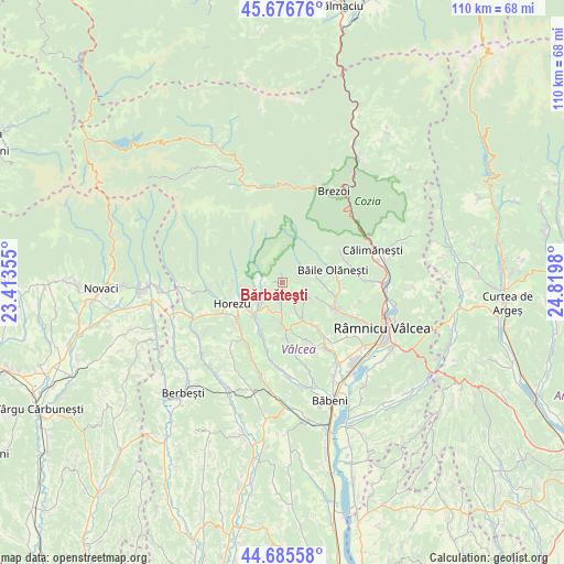
Bărbăteşti GPS coordinates[2]
45° 10' 59.988" North, 24° 7' 0.012" East
| Map corner | latitude | longitude |
|---|---|---|
| Upper-left | 45.67676°, | 23.41355° |
| Center: | 45.18333°, | 24.11667° |
| Lower-right: | 44.68558°, | 24.8198° |
| Map W x H: | 110.2×110.2 km | = 68.5×68.5mi |
| max Lat: | 48.23793° ⇑62.5% North |
| Bărbăteşti: | 45.18333° |
| min Lat: | ⇓37.5% South 43.65638° |
| min Long | Bărbăteşti | max Long |
| 20.31667° | 24.11667° | 29.65403° |
| W 32.5%⇐ | ⇒67.5% E |
Elevation
Elevation of Bărbăteşti is 612 m = 2008 ft, and this is 357.1 m = 1172 ft above average elevation for this country.
| Max E: |
1278 m = 4193 ft | 5.4% |
| Bărbăteşti | 612 m 2008 ft | |
| Avg. | 254.9 m = 836 ft | |
Min E: |
-2 m = -7 ft | 94.6% |
See also: Romania elevation on elevation.city.
Geographical zone
Bărbăteşti is located in North temperate zone (between Tropic of Cancer and the Arctic Circle). Distance of this North polar circle is 2377.3 km =1477.2 mi to North.| Distance of | km | miles | from Bărbăteşti |
|---|---|---|---|
| North Pole | 4983.1 | 3096.4 | to North |
| Arctic Circle | 2377.3 | 1477.2 | to North |
| Tropic Cancer | 2418 | 1502.5 | to South |
| Equator | 5023.9 | 3121.7 | to South |


Nearby cities:
15 places around Bărbăteşti: (largest is in red/bold)
• Bistrița
6 km =3.7 mi,  272°
272°
• Bodești
4.6 km =2.9 mi,  181°
181°
• Bogdănești
8.2 km =5.1 mi,  231°
231°
• Buneşti
9.1 km =5.7 mi,  144°
144°
• Băile Olăneşti
9.3 km =5.8 mi,  78°
78°
• Cheia
7.8 km =4.8 mi,  90°
90°
• Costeşti
5.4 km =3.4 mi, 226°
• Horezu
8.7 km =5.4 mi,  244°
244°
• Livadia
10.1 km =6.3 mi, 75°
• Negrulești
6.2 km =3.9 mi,  200°
200°
• Pietrari
9.4 km =5.8 mi,  171°
171°
• Pietrarii de Sus
7.6 km =4.7 mi,  193°
193°
• Pietreni
4.1 km =2.5 mi,  276°
276°
• Stoeneşti
8.4 km =5.2 mi,  152°
152°
• Tomşani
9.1 km =5.7 mi,  215°
215°
Sources, notices
• [Note1] Compared only with cities in Romania existing in our database
• [Src1] Map data: © OpenStreetMap contributors (CC-BY-SA)
• [Src2] Other city data from geonames.org with taken over terms of usage.
• [Src3] Geographical zone / Annual Mean Temperature by Robert A. Rohde @ Wikipedia
