Moldoveneşti geodata
Moldoveneşti (Cluj) is a seat of a second-order administrative division; located in Romania in Europe/Bucharest (GMT+3) time zone. With population of 3,618 people, there are 1367 cities with bigger population in this country. Compared to other cities in Romania, 67.1% of cities are located further ↓South; 74.9% of cities are located further →East and 89.5% of cities have lower elevation than Moldoveneşti. Note1


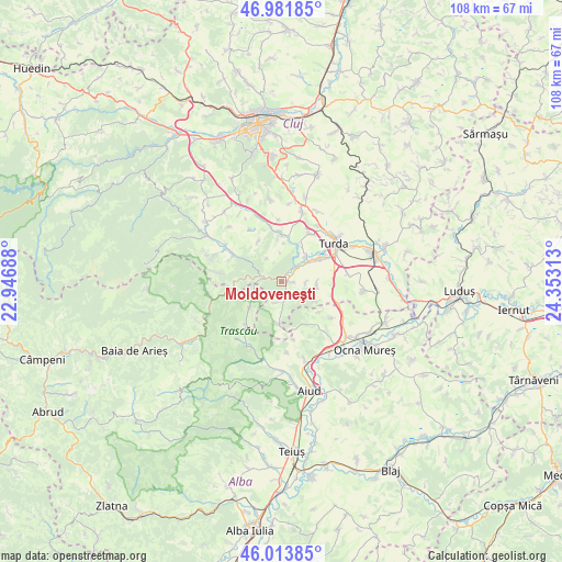
Moldoveneşti GPS coordinates[2]
46° 30' 0" North, 23° 39' 0" East
| Map corner | latitude | longitude |
|---|---|---|
| Upper-left | 46.98185°, | 22.94688° |
| Center: | 46.5°, | 23.65° |
| Lower-right: | 46.01385°, | 24.35313° |
| Map W x H: | 107.6×107.6 km | = 66.9×66.9mi |
| max Lat: | 48.23793° ⇑32.9% North |
| Moldoveneşti: | 46.5° |
| min Lat: | ⇓67.1% South 43.65638° |
| min Long | Moldoveneşti | max Long |
| 20.31667° | 23.65° | 29.65403° |
| W 25.1%⇐ | ⇒74.9% E |
Elevation
Elevation of Moldoveneşti is 505 m = 1657 ft, and this is 250.1 m = 821 ft above average elevation for this country.
| Max E: |
1278 m = 4193 ft | 10.5% |
| Moldoveneşti | 505 m 1657 ft | |
| Avg. | 254.9 m = 836 ft | |
Min E: |
-2 m = -7 ft | 89.5% |
See also: Romania elevation on elevation.city.
Geographical zone
Moldoveneşti is located in North temperate zone (between Tropic of Cancer and the Arctic Circle). Distance of this North polar circle is 2230.9 km =1386.2 mi to North.| Distance of | km | miles | from Moldoveneşti |
|---|---|---|---|
| North Pole | 4836.7 | 3005.4 | to North |
| Arctic Circle | 2230.9 | 1386.2 | to North |
| Tropic Cancer | 2564.4 | 1593.4 | to South |
| Equator | 5170.3 | 3212.7 | to South |


Nearby cities:
15 places around Moldoveneşti: (largest is in red/bold)
• Bogata
12.6 km =7.8 mi,  82°
82°
• Bădeni
6.7 km =4.2 mi,  100°
100°
• Cheia
6.4 km =4 mi,  44°
44°
• Colțești
10.8 km =6.7 mi,  217°
217°
• Copăceni
12.7 km =7.9 mi,  32°
32°
• Cornești
4 km =2.5 mi,  51°
51°
• Iara
11.6 km =7.2 mi,  298°
298°
• Mihai Viteazu
8.5 km =5.3 mi,  64°
64°
• Ocoliş
14.2 km =8.8 mi,  262°
262°
• Petreştii de Jos
9.3 km =5.8 mi,  0°
0°
• Plăiești
4.8 km =3 mi,  93°
93°
• Podeni
8.1 km =5 mi,  184°
184°
• Rimetea
8.5 km =5.3 mi,  228°
228°
• Sănduleşti
10.6 km =6.6 mi, 28°
• Turda
12.6 km =7.8 mi, 53°
Sources, notices
• [Note1] Compared only with cities in Romania existing in our database
• [Src1] Map data: © OpenStreetMap contributors (CC-BY-SA)
• [Src2] Other city data from geonames.org with taken over terms of usage.
• [Src3] Geographical zone / Annual Mean Temperature by Robert A. Rohde @ Wikipedia
