Cerneşti geodata
Cerneşti (Maramureş) is a seat of a second-order administrative division; located in Romania in Europe/Bucharest (GMT+3) time zone. With population of 3,760 people, there are 1291 cities with bigger population in this country. Compared to other cities in Romania, 91.2% of cities are located further ↓South; 73.4% of cities are located further →East and 67.9% of cities have lower elevation than Cerneşti. Note1


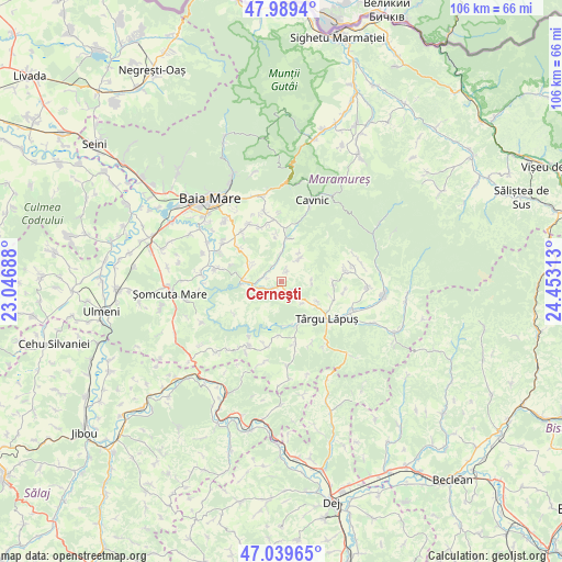
Cerneşti GPS coordinates[2]
47° 31' 0.012" North, 23° 45' 0" East
| Map corner | latitude | longitude |
|---|---|---|
| Upper-left | 47.9894°, | 23.04688° |
| Center: | 47.51667°, | 23.75° |
| Lower-right: | 47.03965°, | 24.45313° |
| Map W x H: | 105.6×105.6 km | = 65.6×65.6mi |
| max Lat: | 48.23793° ⇑8.8% North |
| Cerneşti: | 47.51667° |
| min Lat: | ⇓91.2% South 43.65638° |
| min Long | Cerneşti | max Long |
| 20.31667° | 23.75° | 29.65403° |
| W 26.6%⇐ | ⇒73.4% E |
Elevation
Elevation of Cerneşti is 306 m = 1004 ft, and this is 51.1 m = 168 ft above average elevation for this country.
| Max E: |
1278 m = 4193 ft | 32.1% |
| Cerneşti | 306 m 1004 ft | |
| Avg. | 254.9 m = 836 ft | |
Min E: |
-2 m = -7 ft | 67.9% |
See also: Romania elevation on elevation.city.
Geographical zone
Cerneşti is located in North temperate zone (between Tropic of Cancer and the Arctic Circle). Distance of this North polar circle is 2117.8 km =1315.9 mi to North.| Distance of | km | miles | from Cerneşti |
|---|---|---|---|
| North Pole | 4723.7 | 2935.2 | to North |
| Arctic Circle | 2117.8 | 1315.9 | to North |
| Tropic Cancer | 2677.4 | 1663.7 | to South |
| Equator | 5283.4 | 3283 | to South |


Nearby cities:
15 places around Cerneşti: (largest is in red/bold)
• Berința
6.1 km =3.8 mi,  295°
295°
• Borcut
7.8 km =4.8 mi,  119°
119°
• Cetățele
9.2 km =5.7 mi,  355°
355°
• Ciocotiș
5.7 km =3.5 mi,  38°
38°
• Copalnic
7.1 km =4.4 mi,  273°
273°
• Copalnic Mănăştur
5.3 km =3.3 mi,  249°
249°
• Cărbunari
10.3 km =6.4 mi,  309°
309°
• Fânațe
2.2 km =1.4 mi,  34°
34°
• Făurești
5.2 km =3.2 mi,  0°
0°
• Lăschia
3.3 km =2.1 mi,  335°
335°
• Plopiș
8.3 km =5.2 mi,  11°
11°
• Trestia
6.3 km =3.9 mi, 31°
• Târgu Lăpuş
11.2 km =7 mi,  129°
129°
• Șindrești
10.8 km =6.7 mi, 337°
• Șurdești
9.6 km =6 mi, 8°
Sources, notices
• [Note1] Compared only with cities in Romania existing in our database
• [Src1] Map data: © OpenStreetMap contributors (CC-BY-SA)
• [Src2] Other city data from geonames.org with taken over terms of usage.
• [Src3] Geographical zone / Annual Mean Temperature by Robert A. Rohde @ Wikipedia
