Cepleniţa geodata
Cepleniţa (Iaşi) is a seat of a second-order administrative division; located in Romania in Europe/Bucharest (GMT+3) time zone. With population of 4,533 people, there are 939 cities with bigger population in this country. Compared to other cities in Romania, 88.4% of cities are located further ↓South; 83.1% of cities are located further ←West and 61.7% of cities have higher elevation than Cepleniţa. Note1


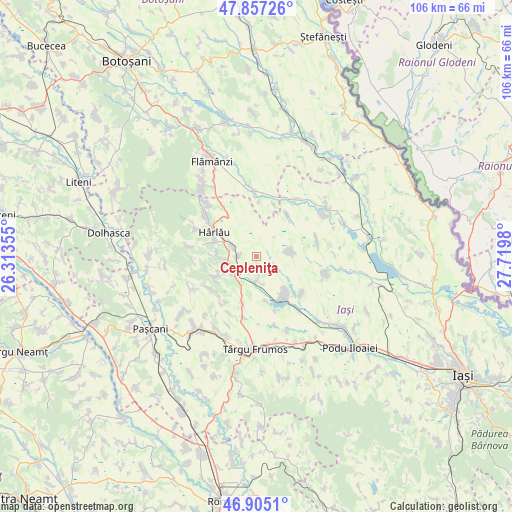
Cepleniţa GPS coordinates[2]
47° 22' 59.988" North, 27° 1' 0.012" East
| Map corner | latitude | longitude |
|---|---|---|
| Upper-left | 47.85726°, | 26.31355° |
| Center: | 47.38333°, | 27.01667° |
| Lower-right: | 46.9051°, | 27.7198° |
| Map W x H: | 105.9×105.9 km | = 65.8×65.8mi |
| max Lat: | 48.23793° ⇑11.6% North |
| Cepleniţa: | 47.38333° |
| min Lat: | ⇓88.4% South 43.65638° |
| min Long | Cepleniţa | max Long |
| 20.31667° | 27.01667° | 29.65403° |
| W 83.1%⇐ | ⇒16.9% E |
Elevation
Elevation of Cepleniţa is 160 m = 525 ft, and this is 94.9 m = 311 ft below average elevation for this country.
| Max E: |
1278 m = 4193 ft | 61.7% |
| Avg. | 254.9 m = 836 ft | |
| Cepleniţa | 160 m = 525 ft | |
Min E: |
-2 m = -7 ft | 38.3% |
See also: Romania elevation on elevation.city.
Geographical zone
Cepleniţa is located in North temperate zone (between Tropic of Cancer and the Arctic Circle). Distance of this North polar circle is 2132.6 km =1325.1 mi to North.| Distance of | km | miles | from Cepleniţa |
|---|---|---|---|
| North Pole | 4738.5 | 2944.4 | to North |
| Arctic Circle | 2132.6 | 1325.1 | to North |
| Tropic Cancer | 2662.6 | 1654.5 | to South |
| Equator | 5268.5 | 3273.7 | to South |


Nearby cities:
15 places around Cepleniţa: (largest is in red/bold)
• Arama
7.5 km =4.7 mi,  77°
77°
• Balș
10.1 km =6.3 mi,  196°
196°
• Buhalnița
7.6 km =4.7 mi,  266°
266°
• Bădeni
5.7 km =3.5 mi,  296°
296°
• Coarnele Caprei
6.3 km =3.9 mi,  90°
90°
• Cotnari
4.5 km =2.8 mi,  214°
214°
• Cârjoaia
9.4 km =5.8 mi,  239°
239°
• Fetești
8.6 km =5.3 mi,  289°
289°
• Hodora
5.1 km =3.2 mi,  177°
177°
• Horodiștea
8.7 km =5.4 mi,  247°
247°
• Liteni
9.2 km =5.7 mi,  169°
169°
• Poiana Mărului
9.4 km =5.8 mi, 267°
• Satu Nou
9.1 km =5.7 mi,  139°
139°
• Scobinţi
6.3 km =3.9 mi, 270°
• Zagavia
9.8 km =6.1 mi, 293°
Sources, notices
• [Note1] Compared only with cities in Romania existing in our database
• [Src1] Map data: © OpenStreetMap contributors (CC-BY-SA)
• [Src2] Other city data from geonames.org with taken over terms of usage.
• [Src3] Geographical zone / Annual Mean Temperature by Robert A. Rohde @ Wikipedia
