Caragele geodata
Caragele (Buzău) is a populated place; located in Romania in Europe/Bucharest (GMT+3) time zone. With population of 963 people, there are 4410 cities with bigger population in this country. Compared to other cities in Romania, 70.5% of cities are located further ↑North; 83.6% of cities are located further ←West and 88.9% of cities have higher elevation than Caragele. Note1


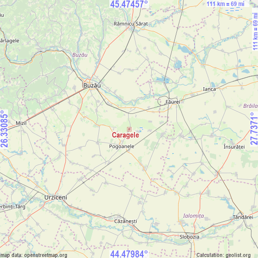
Caragele GPS coordinates[2]
44° 58' 45.696" North, 27° 2' 2.292" East
| Map corner | latitude | longitude |
|---|---|---|
| Upper-left | 45.47457°, | 26.33085° |
| Center: | 44.97936°, | 27.03397° |
| Lower-right: | 44.47984°, | 27.7371° |
| Map W x H: | 110.6×110.6 km | = 68.7×68.7mi |
| max Lat: | 48.23793° ⇑70.5% North |
| Caragele: | 44.97936° |
| min Lat: | ⇓29.5% South 43.65638° |
| min Long | Caragele | max Long |
| 20.31667° | 27.03397° | 29.65403° |
| W 83.6%⇐ | ⇒16.4% E |
Elevation
Elevation of Caragele is 63 m = 207 ft, and this is 191.9 m = 630 ft below average elevation for this country.
| Max E: |
1278 m = 4193 ft | 88.9% |
| Avg. | 254.9 m = 836 ft | |
| Caragele | 63 m = 207 ft | |
Min E: |
-2 m = -7 ft | 11.1% |
See also: Romania elevation on elevation.city.
Geographical zone
Caragele is located in North temperate zone (between Tropic of Cancer and the Arctic Circle). Distance of this Northern Tropic circle is 2395.3 km =1488.4 mi to South.| Distance of | km | miles | from Caragele |
|---|---|---|---|
| North Pole | 5005.8 | 3110.5 | to North |
| Arctic Circle | 2399.9 | 1491.2 | to North |
| Tropic Cancer | 2395.3 | 1488.4 | to South |
| Equator | 5001.2 | 3107.6 | to South |


Nearby cities:
15 places around Caragele: (largest is in red/bold)
• Albești
8.6 km =5.3 mi,  278°
278°
• Bentu
10.8 km =6.7 mi,  334°
334°
• Bălteni
9.6 km =6 mi,  69°
69°
• C.a. Rosetti
12.8 km =8 mi,  54°
54°
• Cilibia
10 km =6.2 mi,  14°
14°
• Cotu Ciorii
12.6 km =7.8 mi,  42°
42°
• Căldărăști
9.5 km =5.9 mi,  179°
179°
• Călțuna
6.7 km =4.2 mi,  255°
255°
• Găvănești
12.4 km =7.7 mi, 11°
• Largu
9.2 km =5.7 mi,  98°
98°
• Luciu
4.1 km =2.5 mi,  109°
109°
• Movila Oii
6.4 km =4 mi,  27°
27°
• Pogoanele
7.5 km =4.7 mi,  200°
200°
• Săgeata
14 km =8.7 mi,  343°
343°
• Tăbărăști
14.3 km =8.9 mi,  321°
321°
Sources, notices
• [Note1] Compared only with cities in Romania existing in our database
• [Src1] Map data: © OpenStreetMap contributors (CC-BY-SA)
• [Src2] Other city data from geonames.org with taken over terms of usage.
• [Src3] Geographical zone / Annual Mean Temperature by Robert A. Rohde @ Wikipedia
