Călui geodata
Călui (Olt) is a seat of a second-order administrative division; located in Romania in Europe/Bucharest (GMT+3) time zone. With population of 1,111 people, there are 3957 cities with bigger population in this country. Compared to other cities in Romania, 86.5% of cities are located further ↑North; 68.3% of cities are located further →East and 62.1% of cities have higher elevation than Călui. Note1


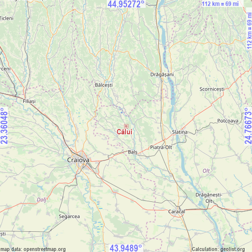
Călui GPS coordinates[2]
44° 27' 10.692" North, 24° 3' 48.96" East
| Map corner | latitude | longitude |
|---|---|---|
| Upper-left | 44.95272°, | 23.36048° |
| Center: | 44.45297°, | 24.0636° |
| Lower-right: | 43.9489°, | 24.76673° |
| Map W x H: | 111.6×111.6 km | = 69.3×69.3mi |
| max Lat: | 48.23793° ⇑86.5% North |
| Călui: | 44.45297° |
| min Lat: | ⇓13.5% South 43.65638° |
| min Long | Călui | max Long |
| 20.31667° | 24.0636° | 29.65403° |
| W 31.7%⇐ | ⇒68.3% E |
Elevation
Elevation of Călui is 158 m = 518 ft, and this is 96.9 m = 318 ft below average elevation for this country.
| Max E: |
1278 m = 4193 ft | 62.1% |
| Avg. | 254.9 m = 836 ft | |
| Călui | 158 m = 518 ft | |
Min E: |
-2 m = -7 ft | 37.9% |
See also: Romania elevation on elevation.city.
Geographical zone
Călui is located in North temperate zone (between Tropic of Cancer and the Arctic Circle). Distance of this Northern Tropic circle is 2336.8 km =1452 mi to South.| Distance of | km | miles | from Călui |
|---|---|---|---|
| North Pole | 5064.4 | 3146.9 | to North |
| Arctic Circle | 2458.5 | 1527.6 | to North |
| Tropic Cancer | 2336.8 | 1452 | to South |
| Equator | 4942.7 | 3071.3 | to South |


Nearby cities:
15 places around Călui: (largest is in red/bold)
• Baldovineşti
7.8 km =4.8 mi,  187°
187°
• Berbești
6.7 km =4.2 mi,  357°
357°
• Băleasa
7.4 km =4.6 mi,  216°
216°
• Cepari
9.9 km =6.2 mi,  59°
59°
• Corbeni
9 km =5.6 mi,  155°
155°
• Cârlogani
9.9 km =6.2 mi,  44°
44°
• Dobriceni
9 km =5.6 mi,  333°
333°
• Gropșani
7.5 km =4.7 mi,  259°
259°
• Gura Căluiu
2.3 km =1.4 mi,  286°
286°
• Găvănești
5.5 km =3.4 mi, 223°
• Horezu
8.4 km =5.2 mi,  283°
283°
• Iancu Jianu
5.8 km =3.6 mi,  335°
335°
• Mologești
8.1 km =5 mi,  351°
351°
• Morunglav
4.5 km =2.8 mi,  70°
70°
• Oboga
5 km =3.1 mi,  144°
144°
Sources, notices
• [Note1] Compared only with cities in Romania existing in our database
• [Src1] Map data: © OpenStreetMap contributors (CC-BY-SA)
• [Src2] Other city data from geonames.org with taken over terms of usage.
• [Src3] Geographical zone / Annual Mean Temperature by Robert A. Rohde @ Wikipedia
