Găvănești geodata
Găvănești (Olt) is a seat of a second-order administrative division; located in Romania in Europe/Bucharest (GMT+3) time zone. With population of 840 people, there are 4882 cities with bigger population in this country. Compared to other cities in Romania, 87.6% of cities are located further ↑North; 69.1% of cities are located further →East and 66.5% of cities have higher elevation than Găvănești. Note1


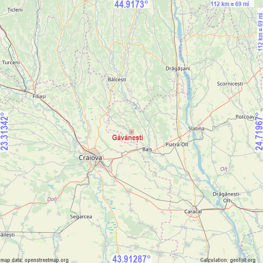
Găvănești GPS coordinates[2]
44° 25' 2.064" North, 24° 0' 59.544" East
| Map corner | latitude | longitude |
|---|---|---|
| Upper-left | 44.9173°, | 23.31342° |
| Center: | 44.41724°, | 24.01654° |
| Lower-right: | 43.91287°, | 24.71967° |
| Map W x H: | 111.7×111.7 km | = 69.4×69.4mi |
| max Lat: | 48.23793° ⇑87.6% North |
| Găvănești: | 44.41724° |
| min Lat: | ⇓12.4% South 43.65638° |
| min Long | Găvănești | max Long |
| 20.31667° | 24.01654° | 29.65403° |
| W 30.9%⇐ | ⇒69.1% E |
Elevation
Elevation of Găvănești is 141 m = 463 ft, and this is 113.9 m = 374 ft below average elevation for this country.
| Max E: |
1278 m = 4193 ft | 66.5% |
| Avg. | 254.9 m = 836 ft | |
| Găvănești | 141 m = 463 ft | |
Min E: |
-2 m = -7 ft | 33.5% |
See also: Romania elevation on elevation.city.
Geographical zone
Găvănești is located in North temperate zone (between Tropic of Cancer and the Arctic Circle). Distance of this Northern Tropic circle is 2332.8 km =1449.5 mi to South.| Distance of | km | miles | from Găvănești |
|---|---|---|---|
| North Pole | 5068.3 | 3149.3 | to North |
| Arctic Circle | 2462.4 | 1530.1 | to North |
| Tropic Cancer | 2332.8 | 1449.5 | to South |
| Equator | 4938.7 | 3068.8 | to South |


Nearby cities:
15 places around Găvănești: (largest is in red/bold)
• Baldovineşti
4.6 km =2.9 mi,  144°
144°
• Balş
10 km =6.2 mi, 138°
• Băleasa
2.1 km =1.3 mi,  197°
197°
• Corbeni
8.5 km =5.3 mi,  119°
119°
• Câmpeni
5.5 km =3.4 mi,  181°
181°
• Călui
5.5 km =3.4 mi,  43°
43°
• Gropșani
4.5 km =2.8 mi,  305°
305°
• Gura Căluiu
4.9 km =3 mi,  17°
17°
• Horezu
7.4 km =4.6 mi,  322°
322°
• Iancu Jianu
9.3 km =5.8 mi,  8°
8°
• Morunglav
9.7 km =6 mi,  55°
55°
• Oboga
6.6 km =4.1 mi,  90°
90°
• Pescărești
7 km =4.3 mi,  298°
298°
• Robăneștii de Sus
10.6 km =6.6 mi, 184°
• Vulpeni
9.6 km =6 mi, 304°
Sources, notices
• [Note1] Compared only with cities in Romania existing in our database
• [Src1] Map data: © OpenStreetMap contributors (CC-BY-SA)
• [Src2] Other city data from geonames.org with taken over terms of usage.
• [Src3] Geographical zone / Annual Mean Temperature by Robert A. Rohde @ Wikipedia
