Corbeni geodata
Corbeni (Olt) is a section of populated place; located in Romania in Europe/Bucharest (GMT+3) time zone. With population of 722 people, there are 5452 cities with bigger population in this country. Compared to other cities in Romania, 88.8% of cities are located further ↑North; 67.6% of cities are located further →East and 69.3% of cities have higher elevation than Corbeni. Note1


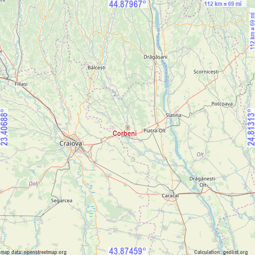
Corbeni GPS coordinates[2]
44° 22' 45.444" North, 24° 6' 36" East
| Map corner | latitude | longitude |
|---|---|---|
| Upper-left | 44.87967°, | 23.40688° |
| Center: | 44.37929°, | 24.11° |
| Lower-right: | 43.87459°, | 24.81313° |
| Map W x H: | 111.8×111.8 km | = 69.5×69.5mi |
| max Lat: | 48.23793° ⇑88.8% North |
| Corbeni: | 44.37929° |
| min Lat: | ⇓11.2% South 43.65638° |
| min Long | Corbeni | max Long |
| 20.31667° | 24.11° | 29.65403° |
| W 32.4%⇐ | ⇒67.6% E |
Elevation
Elevation of Corbeni is 130 m = 427 ft, and this is 124.9 m = 410 ft below average elevation for this country.
| Max E: |
1278 m = 4193 ft | 69.3% |
| Avg. | 254.9 m = 836 ft | |
| Corbeni | 130 m = 427 ft | |
Min E: |
-2 m = -7 ft | 30.7% |
See also: Romania elevation on elevation.city.
Geographical zone
Corbeni is located in North temperate zone (between Tropic of Cancer and the Arctic Circle). Distance of this Northern Tropic circle is 2328.6 km =1446.9 mi to South.| Distance of | km | miles | from Corbeni |
|---|---|---|---|
| North Pole | 5072.5 | 3151.9 | to North |
| Arctic Circle | 2466.7 | 1532.7 | to North |
| Tropic Cancer | 2328.6 | 1446.9 | to South |
| Equator | 4934.5 | 3066.2 | to South |


Nearby cities:
15 places around Corbeni: (largest is in red/bold)
• Baldovineşti
4.8 km =3 mi,  275°
275°
• Balş
3.4 km =2.1 mi,  193°
193°
• Bobiceşti
3.2 km =2 mi,  81°
81°
• Braneț
8 km =5 mi,  137°
137°
• Bârza
6.2 km =3.9 mi,  155°
155°
• Băleasa
8.4 km =5.2 mi,  285°
285°
• Câmpeni
7.7 km =4.8 mi,  260°
260°
• Călui
9 km =5.6 mi,  335°
335°
• Găvănești
8.5 km =5.3 mi,  299°
299°
• Leotești
3.6 km =2.2 mi,  112°
112°
• Mirila
4.1 km =2.5 mi,  125°
125°
• Mărgăritești
9.5 km =5.9 mi, 161°
• Oboga
4.2 km =2.6 mi,  349°
349°
• Racovița
7.2 km =4.5 mi,  173°
173°
• Teiș
3.7 km =2.3 mi,  150°
150°
Sources, notices
• [Note1] Compared only with cities in Romania existing in our database
• [Src1] Map data: © OpenStreetMap contributors (CC-BY-SA)
• [Src2] Other city data from geonames.org with taken over terms of usage.
• [Src3] Geographical zone / Annual Mean Temperature by Robert A. Rohde @ Wikipedia
