Călineşti geodata
Călineşti (Teleorman) is a seat of a second-order administrative division; located in Romania in Europe/Bucharest (GMT+3) time zone. With population of 3,964 people, there are 1176 cities with bigger population in this country. Compared to other cities in Romania, 95.8% of cities are located further ↑North; 50.3% of cities are located further ←West and 83.5% of cities have higher elevation than Călineşti. Note1


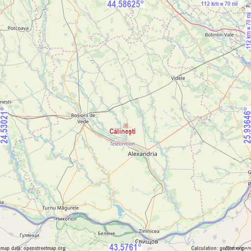
Călineşti GPS coordinates[2]
44° 4' 59.988" North, 25° 13' 59.988" East
| Map corner | latitude | longitude |
|---|---|---|
| Upper-left | 44.58625°, | 24.53021° |
| Center: | 44.08333°, | 25.23333° |
| Lower-right: | 43.5761°, | 25.93646° |
| Map W x H: | 112.3×112.3 km | = 69.8×69.8mi |
| max Lat: | 48.23793° ⇑95.8% North |
| Călineşti: | 44.08333° |
| min Lat: | ⇓4.2% South 43.65638° |
| min Long | Călineşti | max Long |
| 20.31667° | 25.23333° | 29.65403° |
| W 50.3%⇐ | ⇒49.7% E |
Elevation
Elevation of Călineşti is 83 m = 272 ft, and this is 171.9 m = 564 ft below average elevation for this country.
| Max E: |
1278 m = 4193 ft | 83.5% |
| Avg. | 254.9 m = 836 ft | |
| Călineşti | 83 m = 272 ft | |
Min E: |
-2 m = -7 ft | 16.5% |
See also: Romania elevation on elevation.city.
Geographical zone
Călineşti is located in North temperate zone (between Tropic of Cancer and the Arctic Circle). Distance of this Northern Tropic circle is 2295.7 km =1426.5 mi to South.| Distance of | km | miles | from Călineşti |
|---|---|---|---|
| North Pole | 5105.5 | 3172.4 | to North |
| Arctic Circle | 2499.6 | 1553.2 | to North |
| Tropic Cancer | 2295.7 | 1426.5 | to South |
| Equator | 4901.6 | 3045.7 | to South |


Nearby cities:
15 places around Călineşti: (largest is in red/bold)
• Albești
9.2 km =5.7 mi,  259°
259°
• Buzescu
7.4 km =4.6 mi,  180°
180°
• Cetatea
7.8 km =4.8 mi,  317°
317°
• Copăceanca
5.7 km =3.5 mi,  346°
346°
• Dulceanca
10.1 km =6.3 mi,  274°
274°
• Licuriciu
3.4 km =2.1 mi,  298°
298°
• Lăceni
7.9 km =4.9 mi,  88°
88°
• Mavrodin
5.7 km =3.5 mi,  166°
166°
• Nanov
10.7 km =6.6 mi,  150°
150°
• Nenciulești
6 km =3.7 mi,  205°
205°
• Orbeasca de Jos
8.8 km =5.5 mi,  60°
60°
• Orbeasca de Sus
10 km =6.2 mi,  41°
41°
• Plosca
9.7 km =6 mi,  235°
235°
• Păru Rotund
6.8 km =4.2 mi,  227°
227°
• Rădoiești-Vale
9.5 km =5.9 mi, 317°
Sources, notices
• [Note1] Compared only with cities in Romania existing in our database
• [Src1] Map data: © OpenStreetMap contributors (CC-BY-SA)
• [Src2] Other city data from geonames.org with taken over terms of usage.
• [Src3] Geographical zone / Annual Mean Temperature by Robert A. Rohde @ Wikipedia
