Budeni geodata
Budeni (Giurgiu) is a populated place; located in Romania in Europe/Bucharest (GMT+3) time zone. With population of 965 people, there are 4402 cities with bigger population in this country. Compared to other cities in Romania, 93.5% of cities are located further ↑North; 65.2% of cities are located further ←West and 92.6% of cities have higher elevation than Budeni. Note1


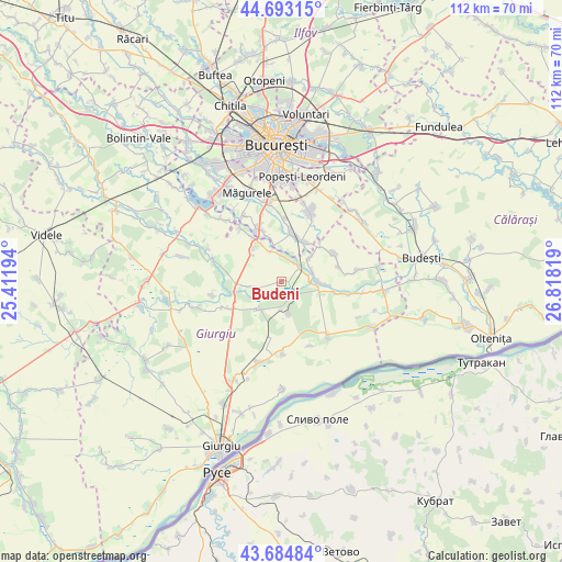
Budeni GPS coordinates[2]
44° 11' 28.14" North, 26° 6' 54.216" East
| Map corner | latitude | longitude |
|---|---|---|
| Upper-left | 44.69315°, | 25.41194° |
| Center: | 44.19115°, | 26.11506° |
| Lower-right: | 43.68484°, | 26.81819° |
| Map W x H: | 112.1×112.1 km | = 69.7×69.7mi |
| max Lat: | 48.23793° ⇑93.5% North |
| Budeni: | 44.19115° |
| min Lat: | ⇓6.5% South 43.65638° |
| min Long | Budeni | max Long |
| 20.31667° | 26.11506° | 29.65403° |
| W 65.2%⇐ | ⇒34.8% E |
Elevation
Elevation of Budeni is 46 m = 151 ft, and this is 208.9 m = 685 ft below average elevation for this country.
| Max E: |
1278 m = 4193 ft | 92.6% |
| Avg. | 254.9 m = 836 ft | |
| Budeni | 46 m = 151 ft | |
Min E: |
-2 m = -7 ft | 7.4% |
See also: Romania elevation on elevation.city.
Geographical zone
Budeni is located in North temperate zone (between Tropic of Cancer and the Arctic Circle). Distance of this Northern Tropic circle is 2307.7 km =1433.9 mi to South.| Distance of | km | miles | from Budeni |
|---|---|---|---|
| North Pole | 5093.5 | 3165 | to North |
| Arctic Circle | 2487.6 | 1545.7 | to North |
| Tropic Cancer | 2307.7 | 1433.9 | to South |
| Equator | 4913.6 | 3053.2 | to South |


Nearby cities:
15 places around Budeni: (largest is in red/bold)
• Adunații-Copăceni
8.7 km =5.4 mi,  323°
323°
• Brăniștari
4.7 km =2.9 mi,  249°
249°
• Colibaşi
6.5 km =4 mi,  79°
79°
• Comana
3.3 km =2.1 mi,  133°
133°
• Copăceni
8.2 km =5.1 mi,  347°
347°
• Câmpurelu
7.5 km =4.7 mi,  50°
50°
• Falaștoaca
5.6 km =3.5 mi,  90°
90°
• Gostinari
9 km =5.6 mi, 93°
• Goştinari-Văcăreşti
8.1 km =5 mi,  96°
96°
• Grădiștea
4.6 km =2.9 mi,  61°
61°
• Mihai Bravu
7 km =4.3 mi,  216°
216°
• Mogoșești
5.6 km =3.5 mi, 353°
• Varlaam
6.3 km =3.9 mi,  342°
342°
• Vidra
8.9 km =5.5 mi,  29°
29°
• Vlad Țepeș
6.7 km =4.2 mi,  167°
167°
Sources, notices
• [Note1] Compared only with cities in Romania existing in our database
• [Src1] Map data: © OpenStreetMap contributors (CC-BY-SA)
• [Src2] Other city data from geonames.org with taken over terms of usage.
• [Src3] Geographical zone / Annual Mean Temperature by Robert A. Rohde @ Wikipedia
