Bucşani geodata
Bucşani (Giurgiu) is a seat of a second-order administrative division; located in Romania in Europe/Bucharest (GMT+3) time zone. With population of 3,959 people, there are 1183 cities with bigger population in this country. Compared to other cities in Romania, 88.9% of cities are located further ↑North; 57% of cities are located further ←West and 80.5% of cities have higher elevation than Bucşani. Note1


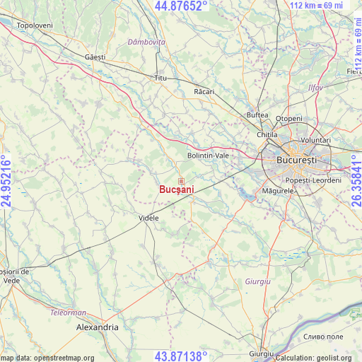
Bucşani GPS coordinates[2]
44° 22' 33.996" North, 25° 39' 19.008" East
| Map corner | latitude | longitude |
|---|---|---|
| Upper-left | 44.87652°, | 24.95216° |
| Center: | 44.37611°, | 25.65528° |
| Lower-right: | 43.87138°, | 26.35841° |
| Map W x H: | 111.8×111.8 km | = 69.5×69.5mi |
| max Lat: | 48.23793° ⇑88.9% North |
| Bucşani: | 44.37611° |
| min Lat: | ⇓11.1% South 43.65638° |
| min Long | Bucşani | max Long |
| 20.31667° | 25.65528° | 29.65403° |
| W 57%⇐ | ⇒43% E |
Elevation
Elevation of Bucşani is 93 m = 305 ft, and this is 161.9 m = 531 ft below average elevation for this country.
| Max E: |
1278 m = 4193 ft | 80.5% |
| Avg. | 254.9 m = 836 ft | |
| Bucşani | 93 m = 305 ft | |
Min E: |
-2 m = -7 ft | 19.5% |
See also: Romania elevation on elevation.city.
Geographical zone
Bucşani is located in North temperate zone (between Tropic of Cancer and the Arctic Circle). Distance of this Northern Tropic circle is 2328.2 km =1446.7 mi to South.| Distance of | km | miles | from Bucşani |
|---|---|---|---|
| North Pole | 5072.9 | 3152.2 | to North |
| Arctic Circle | 2467 | 1532.9 | to North |
| Tropic Cancer | 2328.2 | 1446.7 | to South |
| Equator | 4934.2 | 3066 | to South |


Nearby cities:
15 places around Bucşani: (largest is in red/bold)
• Clejani
7.2 km =4.5 mi,  150°
150°
• Crevedia Mare
6.4 km =4 mi,  338°
338°
• Crevedia Mică
8.1 km =5 mi,  333°
333°
• Dealu
2.6 km =1.6 mi,  348°
348°
• Goleasca
5.6 km =3.5 mi,  247°
247°
• Hobaia
9.7 km =6 mi,  81°
81°
• Malu Spart
9 km =5.6 mi,  33°
33°
• Mârşa
7.8 km =4.8 mi,  268°
268°
• Ogrezeni
10.2 km =6.3 mi,  61°
61°
• Podișor
5 km =3.1 mi,  71°
71°
• Podu Doamnei
10.4 km =6.5 mi,  136°
136°
• Roata Mică
8.2 km =5.1 mi,  288°
288°
• Roata de Jos
9.7 km =6 mi, 293°
• Suseni
9 km =5.6 mi,  20°
20°
• Vadu Lat
3.8 km =2.4 mi, 154°
Sources, notices
• [Note1] Compared only with cities in Romania existing in our database
• [Src1] Map data: © OpenStreetMap contributors (CC-BY-SA)
• [Src2] Other city data from geonames.org with taken over terms of usage.
• [Src3] Geographical zone / Annual Mean Temperature by Robert A. Rohde @ Wikipedia
