Clejani geodata
Clejani (Giurgiu) is a seat of a second-order administrative division; located in Romania in Europe/Bucharest (GMT+3) time zone. With population of 3,414 people, there are 1483 cities with bigger population in this country. Compared to other cities in Romania, 90.2% of cities are located further ↑North; 57.5% of cities are located further ←West and 83.5% of cities have higher elevation than Clejani. Note1


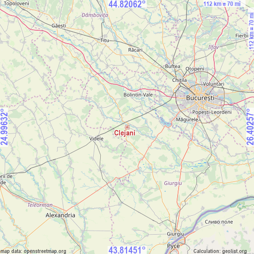
Clejani GPS coordinates[2]
44° 19' 10.992" North, 25° 41' 57.984" East
| Map corner | latitude | longitude |
|---|---|---|
| Upper-left | 44.82062°, | 24.99632° |
| Center: | 44.31972°, | 25.69944° |
| Lower-right: | 43.81451°, | 26.40257° |
| Map W x H: | 111.9×111.9 km | = 69.5×69.5mi |
| max Lat: | 48.23793° ⇑90.2% North |
| Clejani: | 44.31972° |
| min Lat: | ⇓9.8% South 43.65638° |
| min Long | Clejani | max Long |
| 20.31667° | 25.69944° | 29.65403° |
| W 57.5%⇐ | ⇒42.5% E |
Elevation
Elevation of Clejani is 83 m = 272 ft, and this is 171.9 m = 564 ft below average elevation for this country.
| Max E: |
1278 m = 4193 ft | 83.5% |
| Avg. | 254.9 m = 836 ft | |
| Clejani | 83 m = 272 ft | |
Min E: |
-2 m = -7 ft | 16.5% |
See also: Romania elevation on elevation.city.
Geographical zone
Clejani is located in North temperate zone (between Tropic of Cancer and the Arctic Circle). Distance of this Northern Tropic circle is 2322 km =1442.8 mi to South.| Distance of | km | miles | from Clejani |
|---|---|---|---|
| North Pole | 5079.2 | 3156.1 | to North |
| Arctic Circle | 2473.3 | 1536.8 | to North |
| Tropic Cancer | 2322 | 1442.8 | to South |
| Equator | 4927.9 | 3062.1 | to South |


Nearby cities:
15 places around Clejani: (largest is in red/bold)
• Bucşani
7.2 km =4.5 mi,  330°
330°
• Bulbucata
9.2 km =5.7 mi,  116°
116°
• Ciuani
10.4 km =6.5 mi,  202°
202°
• Coșoaia
7.4 km =4.6 mi,  231°
231°
• Dealu
9.7 km =6 mi,  335°
335°
• Goleasca
9.6 km =6 mi,  295°
295°
• Hobaia
9.9 km =6.2 mi,  38°
38°
• Letca Nouă
10 km =6.2 mi,  159°
159°
• Merenii de Jos
10.7 km =6.6 mi, 204°
• Milcovățu
6 km =3.7 mi,  180°
180°
• Neajlovu
4.5 km =2.8 mi,  97°
97°
• Podișor
7.9 km =4.9 mi,  8°
8°
• Podu Doamnei
3.9 km =2.4 mi,  109°
109°
• Pădureni
8.9 km =5.5 mi,  70°
70°
• Vadu Lat
3.4 km =2.1 mi, 326°
Sources, notices
• [Note1] Compared only with cities in Romania existing in our database
• [Src1] Map data: © OpenStreetMap contributors (CC-BY-SA)
• [Src2] Other city data from geonames.org with taken over terms of usage.
• [Src3] Geographical zone / Annual Mean Temperature by Robert A. Rohde @ Wikipedia
