Broşteni geodata
Broşteni (Mehedinţi) is a seat of a second-order administrative division; located in Romania in Europe/Bucharest (GMT+3) time zone. With population of 3,017 people, there are 1749 cities with bigger population in this country. Compared to other cities in Romania, 78.1% of cities are located further ↑North; 84.7% of cities are located further →East and 55.8% of cities have higher elevation than Broşteni. Note1


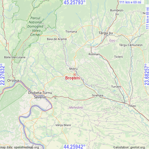
Broşteni GPS coordinates[2]
44° 45' 38.988" North, 22° 58' 45.984" East
| Map corner | latitude | longitude |
|---|---|---|
| Upper-left | 45.25793°, | 22.27632° |
| Center: | 44.76083°, | 22.97944° |
| Lower-right: | 44.25942°, | 23.68257° |
| Map W x H: | 111×111 km | = 69×69mi |
| max Lat: | 48.23793° ⇑78.1% North |
| Broşteni: | 44.76083° |
| min Lat: | ⇓21.9% South 43.65638° |
| min Long | Broşteni | max Long |
| 20.31667° | 22.97944° | 29.65403° |
| W 15.3%⇐ | ⇒84.7% E |
Elevation
Elevation of Broşteni is 183 m = 600 ft, and this is 71.9 m = 236 ft below average elevation for this country.
| Max E: |
1278 m = 4193 ft | 55.8% |
| Avg. | 254.9 m = 836 ft | |
| Broşteni | 183 m = 600 ft | |
Min E: |
-2 m = -7 ft | 44.2% |
See also: Romania elevation on elevation.city.
Geographical zone
Broşteni is located in North temperate zone (between Tropic of Cancer and the Arctic Circle). Distance of this Northern Tropic circle is 2371 km =1473.3 mi to South.| Distance of | km | miles | from Broşteni |
|---|---|---|---|
| North Pole | 5030.1 | 3125.6 | to North |
| Arctic Circle | 2424.2 | 1506.3 | to North |
| Tropic Cancer | 2371 | 1473.3 | to South |
| Equator | 4976.9 | 3092.5 | to South |


Nearby cities:
15 places around Broşteni: (largest is in red/bold)
• Corcova
8.8 km =5.5 mi,  140°
140°
• Căzăneşti
8.2 km =5.1 mi,  239°
239°
• Floreşti
2.5 km =1.6 mi,  275°
275°
• Gârdoaia
4.4 km =2.7 mi, 276°
• Horăști
3.9 km =2.4 mi,  44°
44°
• Lupoaia
6.1 km =3.8 mi,  346°
346°
• Lupșa de Jos
3.5 km =2.2 mi,  158°
158°
• Lupșa de Sus
4.1 km =2.5 mi,  218°
218°
• Meriș
2.4 km =1.5 mi,  357°
357°
• Miculești
8.7 km =5.4 mi, 36°
• Motru
4.8 km =3 mi, 352°
• Ploștina
7.1 km =4.4 mi,  5°
5°
• Samarineşti
5.7 km =3.5 mi,  102°
102°
• Severinești
7.9 km =4.9 mi,  199°
199°
• Zegujani
7.3 km =4.5 mi,  316°
316°
Sources, notices
• [Note1] Compared only with cities in Romania existing in our database
• [Src1] Map data: © OpenStreetMap contributors (CC-BY-SA)
• [Src2] Other city data from geonames.org with taken over terms of usage.
• [Src3] Geographical zone / Annual Mean Temperature by Robert A. Rohde @ Wikipedia
