Horăști geodata
Horăști (Gorj) is a populated place; located in Romania in Europe/Bucharest (GMT+3) time zone. With population of 579 people, there are 6363 cities with bigger population in this country. Compared to other cities in Romania, 77.1% of cities are located further ↑North; 84.3% of cities are located further →East and 50.5% of cities have higher elevation than Horăști. Note1


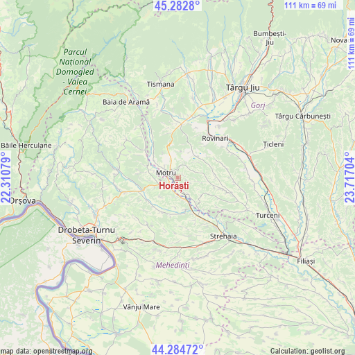
Horăști GPS coordinates[2]
44° 47' 9.312" North, 23° 0' 50.076" East
| Map corner | latitude | longitude |
|---|---|---|
| Upper-left | 45.2828°, | 22.31079° |
| Center: | 44.78592°, | 23.01391° |
| Lower-right: | 44.28472°, | 23.71704° |
| Map W x H: | 111×111 km | = 69×69mi |
| max Lat: | 48.23793° ⇑77.1% North |
| Horăști: | 44.78592° |
| min Lat: | ⇓22.9% South 43.65638° |
| min Long | Horăști | max Long |
| 20.31667° | 23.01391° | 29.65403° |
| W 15.7%⇐ | ⇒84.3% E |
Elevation
Elevation of Horăști is 209 m = 686 ft, and this is 45.9 m = 151 ft below average elevation for this country.
| Max E: |
1278 m = 4193 ft | 50.5% |
| Avg. | 254.9 m = 836 ft | |
| Horăști | 209 m = 686 ft | |
Min E: |
-2 m = -7 ft | 49.5% |
See also: Romania elevation on elevation.city.
Geographical zone
Horăști is located in North temperate zone (between Tropic of Cancer and the Arctic Circle). Distance of this Northern Tropic circle is 2373.8 km =1475 mi to South.| Distance of | km | miles | from Horăști |
|---|---|---|---|
| North Pole | 5027.3 | 3123.8 | to North |
| Arctic Circle | 2421.4 | 1504.6 | to North |
| Tropic Cancer | 2373.8 | 1475 | to South |
| Equator | 4979.7 | 3094.2 | to South |


Nearby cities:
15 places around Horăști: (largest is in red/bold)
• Broşteni
3.9 km =2.4 mi,  224°
224°
• Croici
8.3 km =5.2 mi,  52°
52°
• Floreşti
5.8 km =3.6 mi,  244°
244°
• Gârdoaia
7.4 km =4.6 mi,  251°
251°
• Lupoaia
5.2 km =3.2 mi,  307°
307°
• Lupșa de Jos
6.2 km =3.9 mi,  193°
193°
• Lupșa de Sus
8 km =5 mi, 221°
• Meriș
2.8 km =1.7 mi,  262°
262°
• Miculești
4.9 km =3 mi,  30°
30°
• Motru
3.8 km =2.4 mi,  300°
300°
• Ploștina
4.7 km =2.9 mi,  334°
334°
• Runcurel
8.1 km =5 mi,  3°
3°
• Samarineşti
4.9 km =3 mi,  144°
144°
• Strâmtu
7.9 km =4.9 mi,  97°
97°
• Zegujani
8.2 km =5.1 mi,  287°
287°
Sources, notices
• [Note1] Compared only with cities in Romania existing in our database
• [Src1] Map data: © OpenStreetMap contributors (CC-BY-SA)
• [Src2] Other city data from geonames.org with taken over terms of usage.
• [Src3] Geographical zone / Annual Mean Temperature by Robert A. Rohde @ Wikipedia
