Boroșești geodata
Boroșești (Iaşi) is a populated place; located in Romania in Europe/Bucharest (GMT+3) time zone. With population of 878 people, there are 4714 cities with bigger population in this country. Compared to other cities in Romania, 77.7% of cities are located further ↓South; 92.1% of cities are located further ←West and 51% of cities have lower elevation than Boroșești. Note1


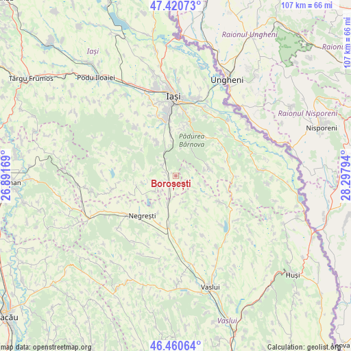
Boroșești GPS coordinates[2]
46° 56' 34.224" North, 27° 35' 41.316" East
| Map corner | latitude | longitude |
|---|---|---|
| Upper-left | 47.42073°, | 26.89169° |
| Center: | 46.94284°, | 27.59481° |
| Lower-right: | 46.46064°, | 28.29794° |
| Map W x H: | 106.8×106.8 km | = 66.4×66.4mi |
| max Lat: | 48.23793° ⇑22.3% North |
| Boroșești: | 46.94284° |
| min Lat: | ⇓77.7% South 43.65638° |
| min Long | Boroșești | max Long |
| 20.31667° | 27.59481° | 29.65403° |
| W 92.1%⇐ | ⇒7.9% E |
Elevation
Elevation of Boroșești is 217 m = 712 ft, and this is 37.9 m = 124 ft below average elevation for this country.
| Max E: |
1278 m = 4193 ft | 49% |
| Avg. | 254.9 m = 836 ft | |
| Boroșești | 217 m = 712 ft | |
Min E: |
-2 m = -7 ft | 51% |
See also: Romania elevation on elevation.city.
Geographical zone
Boroșești is located in North temperate zone (between Tropic of Cancer and the Arctic Circle). Distance of this North polar circle is 2181.6 km =1355.6 mi to North.| Distance of | km | miles | from Boroșești |
|---|---|---|---|
| North Pole | 4787.5 | 2974.8 | to North |
| Arctic Circle | 2181.6 | 1355.6 | to North |
| Tropic Cancer | 2613.6 | 1624 | to South |
| Equator | 5219.6 | 3243.3 | to South |


Nearby cities:
15 places around Boroșești: (largest is in red/bold)
• Bâcu
10.5 km =6.5 mi,  258°
258°
• Căuești
4.5 km =2.8 mi,  246°
246°
• Dobrovăţ
8 km =5 mi,  84°
84°
• Draxeni
8.1 km =5 mi,  162°
162°
• Drăgușeni
7.8 km =4.8 mi,  233°
233°
• Emil Racoviță
10.2 km =6.3 mi,  141°
141°
• Focșeașca
3.1 km =1.9 mi,  110°
110°
• Grajduri
6.5 km =4 mi,  294°
294°
• Protopopești
4.2 km =2.6 mi,  53°
53°
• Rebricea
9.1 km =5.7 mi,  201°
201°
• Scânteia
3.6 km =2.2 mi,  216°
216°
• Slobozia
8.6 km =5.3 mi,  10°
10°
• Tăcuta
7.3 km =4.5 mi, 113°
• Valea Satului
3.7 km =2.3 mi, 288°
• Şcheia
6 km =3.7 mi, 259°
Sources, notices
• [Note1] Compared only with cities in Romania existing in our database
• [Src1] Map data: © OpenStreetMap contributors (CC-BY-SA)
• [Src2] Other city data from geonames.org with taken over terms of usage.
• [Src3] Geographical zone / Annual Mean Temperature by Robert A. Rohde @ Wikipedia
