Protopopești geodata
Protopopești (Vaslui) is a populated place; located in Romania in Europe/Bucharest (GMT+3) time zone. With population of 736 people, there are 5362 cities with bigger population in this country. Compared to other cities in Romania, 78.2% of cities are located further ↓South; 92.6% of cities are located further ←West and 54.6% of cities have lower elevation than Protopopești. Note1


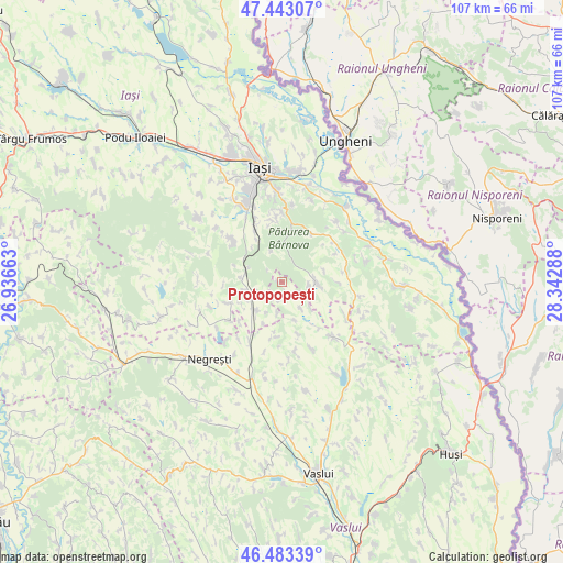
Protopopești GPS coordinates[2]
46° 57' 55.368" North, 27° 38' 23.1" East
| Map corner | latitude | longitude |
|---|---|---|
| Upper-left | 47.44307°, | 26.93663° |
| Center: | 46.96538°, | 27.63975° |
| Lower-right: | 46.48339°, | 28.34288° |
| Map W x H: | 106.7×106.7 km | = 66.3×66.3mi |
| max Lat: | 48.23793° ⇑21.8% North |
| Protopopești: | 46.96538° |
| min Lat: | ⇓78.2% South 43.65638° |
| min Long | Protopopești | max Long |
| 20.31667° | 27.63975° | 29.65403° |
| W 92.6%⇐ | ⇒7.4% E |
Elevation
Elevation of Protopopești is 236 m = 774 ft, and this is 18.9 m = 62 ft below average elevation for this country.
| Max E: |
1278 m = 4193 ft | 45.4% |
| Avg. | 254.9 m = 836 ft | |
| Protopopești | 236 m = 774 ft | |
Min E: |
-2 m = -7 ft | 54.6% |
See also: Romania elevation on elevation.city.
Geographical zone
Protopopești is located in North temperate zone (between Tropic of Cancer and the Arctic Circle). Distance of this North polar circle is 2179.1 km =1354 mi to North.| Distance of | km | miles | from Protopopești |
|---|---|---|---|
| North Pole | 4785 | 2973.3 | to North |
| Arctic Circle | 2179.1 | 1354 | to North |
| Tropic Cancer | 2616.1 | 1625.6 | to South |
| Equator | 5222.1 | 3244.9 | to South |


Nearby cities:
15 places around Protopopești: (largest is in red/bold)
• Boroșești
4.2 km =2.6 mi,  233°
233°
• Ciurea
10.9 km =6.8 mi,  329°
329°
• Căuești
8.7 km =5.4 mi,  240°
240°
• Dobrovăţ
4.9 km =3 mi,  110°
110°
• Draxeni
10.3 km =6.4 mi,  185°
185°
• Emil Racoviță
10.9 km =6.8 mi,  163°
163°
• Focșeașca
3.6 km =2.2 mi, 188°
• Grajduri
9.3 km =5.8 mi,  270°
270°
• Picioru Lupului
9.3 km =5.8 mi, 329°
• Poieni
10.5 km =6.5 mi,  25°
25°
• Scânteia
7.8 km =4.8 mi, 225°
• Slobozia
6.2 km =3.9 mi,  342°
342°
• Tăcuta
6.3 km =3.9 mi,  148°
148°
• Valea Satului
7.1 km =4.4 mi,  259°
259°
• Şcheia
10 km =6.2 mi,  249°
249°
Sources, notices
• [Note1] Compared only with cities in Romania existing in our database
• [Src1] Map data: © OpenStreetMap contributors (CC-BY-SA)
• [Src2] Other city data from geonames.org with taken over terms of usage.
• [Src3] Geographical zone / Annual Mean Temperature by Robert A. Rohde @ Wikipedia
