Borduşani geodata
Borduşani (Ialomiţa) is a seat of a second-order administrative division; located in Romania in Europe/Bucharest (GMT+3) time zone. With population of 5,285 people, there are 699 cities with bigger population in this country. Compared to other cities in Romania, 85.7% of cities are located further ↑North; 95.4% of cities are located further ←West and 97.7% of cities have higher elevation than Borduşani. Note1


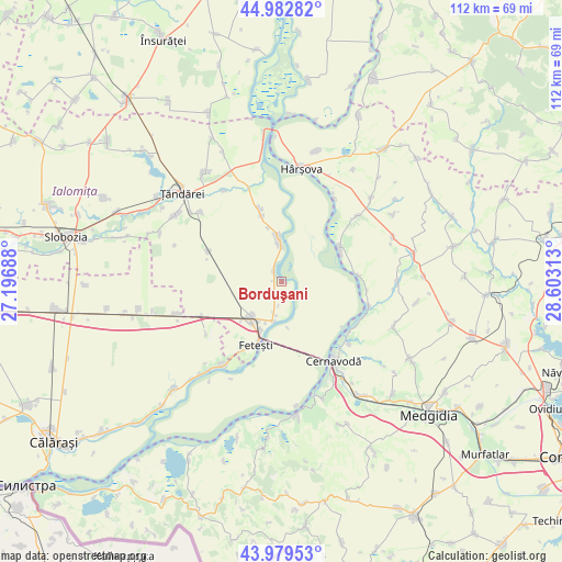
Borduşani GPS coordinates[2]
44° 28' 59.988" North, 27° 54' 0" East
| Map corner | latitude | longitude |
|---|---|---|
| Upper-left | 44.98282°, | 27.19688° |
| Center: | 44.48333°, | 27.9° |
| Lower-right: | 43.97953°, | 28.60313° |
| Map W x H: | 111.6×111.6 km | = 69.3×69.3mi |
| max Lat: | 48.23793° ⇑85.7% North |
| Borduşani: | 44.48333° |
| min Lat: | ⇓14.3% South 43.65638° |
| min Long | Borduşani | max Long |
| 20.31667° | 27.9° | 29.65403° |
| W 95.4%⇐ | ⇒4.6% E |
Elevation
Elevation of Borduşani is 19 m = 62 ft, and this is 235.9 m = 774 ft below average elevation for this country.
| Max E: |
1278 m = 4193 ft | 97.7% |
| Avg. | 254.9 m = 836 ft | |
| Borduşani | 19 m = 62 ft | |
Min E: |
-2 m = -7 ft | 2.3% |
See also: Romania elevation on elevation.city.
Geographical zone
Borduşani is located in North temperate zone (between Tropic of Cancer and the Arctic Circle). Distance of this Northern Tropic circle is 2340.2 km =1454.1 mi to South.| Distance of | km | miles | from Borduşani |
|---|---|---|---|
| North Pole | 5061 | 3144.8 | to North |
| Arctic Circle | 2455.1 | 1525.5 | to North |
| Tropic Cancer | 2340.2 | 1454.1 | to South |
| Equator | 4946.1 | 3073.4 | to South |


Nearby cities:
15 places around Borduşani: (largest is in red/bold)
• Buliga
16.4 km =10.2 mi,  211°
211°
• Cegani
2.3 km =1.4 mi,  176°
176°
• Cernavodă
19.1 km =11.9 mi,  146°
146°
• Dunărea
18 km =11.2 mi,  106°
106°
• Feteşti
12.3 km =7.6 mi, 205°
• Fetești-Gară
9.2 km =5.7 mi,  219°
219°
• Făcăeni
9.3 km =5.8 mi,  0°
0°
• Movila
17.5 km =10.9 mi,  295°
295°
• Progresu
11 km =6.8 mi,  347°
347°
• Seimeni
17.3 km =10.7 mi,  130°
130°
• Seimenii Mici
18.3 km =11.4 mi, 132°
• Stelnica
7.5 km =4.7 mi,  190°
190°
• Topalu
13.4 km =8.3 mi,  59°
59°
• Vlașca
10.5 km =6.5 mi,  202°
202°
• Vlădeni
14.9 km =9.3 mi, 354°
Sources, notices
• [Note1] Compared only with cities in Romania existing in our database
• [Src1] Map data: © OpenStreetMap contributors (CC-BY-SA)
• [Src2] Other city data from geonames.org with taken over terms of usage.
• [Src3] Geographical zone / Annual Mean Temperature by Robert A. Rohde @ Wikipedia
